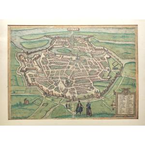
Antique map depicting a view of Colmar, taken from a copy of Münster's Cosmography. Sebastian Münster (1489-1552), humanist scholar, chronicler, and cartographer. Fold in the middle. Map mounted on he[...]
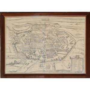
Original engraved map with watercolor highlights, taken from the second volume of three by Peter von Brachel, publisher in Cologne in 1580, three geographers participated in this work "Braun Georg, No[...]
Copper engraving, watercolored by the publisher. This plan appeared in a Latin book published in Cologne in 1572 entitled Civitates orbis terrarum liber primus and subsequently reprinted several times[...]
Beautiful map of the Provence region taken by Pierre-Jean de Bompar in 1591 and published in 1594 for his highness Charles-Emmanuel of Savoy (1562-1630). Please note: -The presence of stains and holes[...]
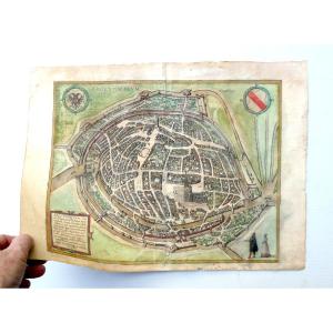
Abbaye Saint-Gall Estampe 1575 Hogenberg Franz graveur
gravure sur cuivre réhaussée à la main en couleur d'origine et tirée du Civites orbis terrarum publié à Cologne
marge supérieure rognée et pli[...]
Geographic map, original proof engraved under the reign of Henri IV in 1594 by (Boguerealdj) Bouguereau cartographer.
Very beautiful proof enhanced with hand-painted watercolor, bright and fresh colo[...]
PORTUGUESE PLANISPHERE
Facsimile of the portolan attributed to Pedro de Lemos, circa 1590.
The original is an illuminated manuscript on vellum kept at the BNF
104 x 197 cm
Frame 120 x 213 cm
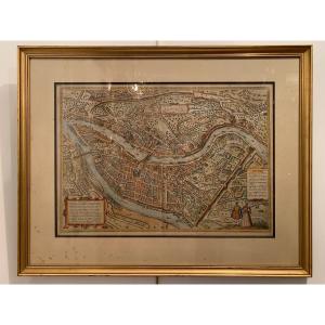
Plan of the city of Metz in 1572, taken from the book "Civitates Orbis Terrarum", and including 564 perspective views of the main cities of the world. The plan is framed in a pitch pine frame with ebo[...]
Due to the famous designer and cartographer Frans Hogenberg (1535-1590), published in famous 1584 work of Georg Braun (1541-1622), this copper engraving, perhaps not colored at period? engraved bowl: [...]
Intitulé Tornacum, gravé sur cuivre et coloré à la main. Ce plan de Tournai (Belgique ) est tiré du célèbre atlas des villes édité en 1588 et intitulé "civitades orbis terrarum".
Bel état général. [...]
Copper engraving by Georg Hoefnagel for "Civitates Orbis Terrarum" Proof in modern colors. German school of the 16th century. Some foxing at the bottom left of the mat (visible in the photo) which doe[...]
Proantic uses a cookie to analyze traffic and improve its service by using Google Analytics. Data sent to Google Analytics (frequency of visits to the site and pages visited) are anonymous. No other cookie tracks your activity, your personal data is not collected. Thank you for helping us to have better understanding how Proantic is used.


 Le Magazine de PROANTIC
 TRÉSORS Magazine
 Rivista Artiquariato