THIS OBJECT WAS SOLD
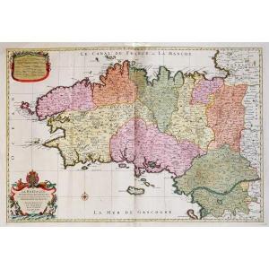
Carte Du Berry Et Son Blason - Rare Engraving - Ep. Mid 17th Century


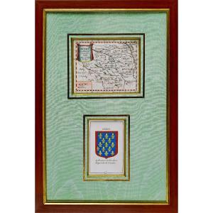


BEAUTIFUL and RARE antique engraving of BERRY
Original intaglio engraving, on laid paper
RARE CARD of BERRY accompanied by the classically shaped BLASON, presenting a field of azure semé de fleurs de lys or, surrounded by a bordure engrêlée de gueules, in keeping with the heraldic tradition of princely apanages from the House of France. The blazon is accompanied at the top by the inscription "BERRI", and at the bottom by an explanatory legend: "de France, à la bordure engrêlée de gueules", describing the blazon in detail.
By Pierre DU VAL D'ABBEVILLE, nephew and pupil of the famous cartographer Nicolas Sanson, whose work he continued by widely distributing maps and descriptive plates of the French provinces. Appointed "Ordinary Geographer to the King" under the reign of Louis XIV, he contributed to the representation and structuring of the kingdom's territory.
Fine hand-watercolored colors.
Dimension(s) : Framing : Height: 39.8 cm - Width: 27 cm - Width. Wand : 2 cm,
Condition : PERFECT CONDITION,
Era : Engraving(s) : MID-SEVIIth (CIRCA 1660),
Framing(s) : ACTUAL - Gold bevel - Passe-partout in water-green moire, thin aged gold fillet - Wooden wand, water gilding.
PAYMENTS ACCEPTED: WIRE TRANSFER / PAYPAL / CB online or by CHEQUE.
PACKAGES WILL BE POSTED WITHIN 4 DAYS.
GROUPED EDITION POSSIBLE IF PURCHASING SEVERAL OBJECTS.
Original intaglio engraving, on laid paper
RARE CARD of BERRY accompanied by the classically shaped BLASON, presenting a field of azure semé de fleurs de lys or, surrounded by a bordure engrêlée de gueules, in keeping with the heraldic tradition of princely apanages from the House of France. The blazon is accompanied at the top by the inscription "BERRI", and at the bottom by an explanatory legend: "de France, à la bordure engrêlée de gueules", describing the blazon in detail.
By Pierre DU VAL D'ABBEVILLE, nephew and pupil of the famous cartographer Nicolas Sanson, whose work he continued by widely distributing maps and descriptive plates of the French provinces. Appointed "Ordinary Geographer to the King" under the reign of Louis XIV, he contributed to the representation and structuring of the kingdom's territory.
Fine hand-watercolored colors.
Dimension(s) : Framing : Height: 39.8 cm - Width: 27 cm - Width. Wand : 2 cm,
Condition : PERFECT CONDITION,
Era : Engraving(s) : MID-SEVIIth (CIRCA 1660),
Framing(s) : ACTUAL - Gold bevel - Passe-partout in water-green moire, thin aged gold fillet - Wooden wand, water gilding.
PAYMENTS ACCEPTED: WIRE TRANSFER / PAYPAL / CB online or by CHEQUE.
PACKAGES WILL BE POSTED WITHIN 4 DAYS.
GROUPED EDITION POSSIBLE IF PURCHASING SEVERAL OBJECTS.
Explore similar pieces and discover your ideal find:
Old Maps