THIS OBJECT WAS SOLD
Old Engraving Of The City Of Auxerre
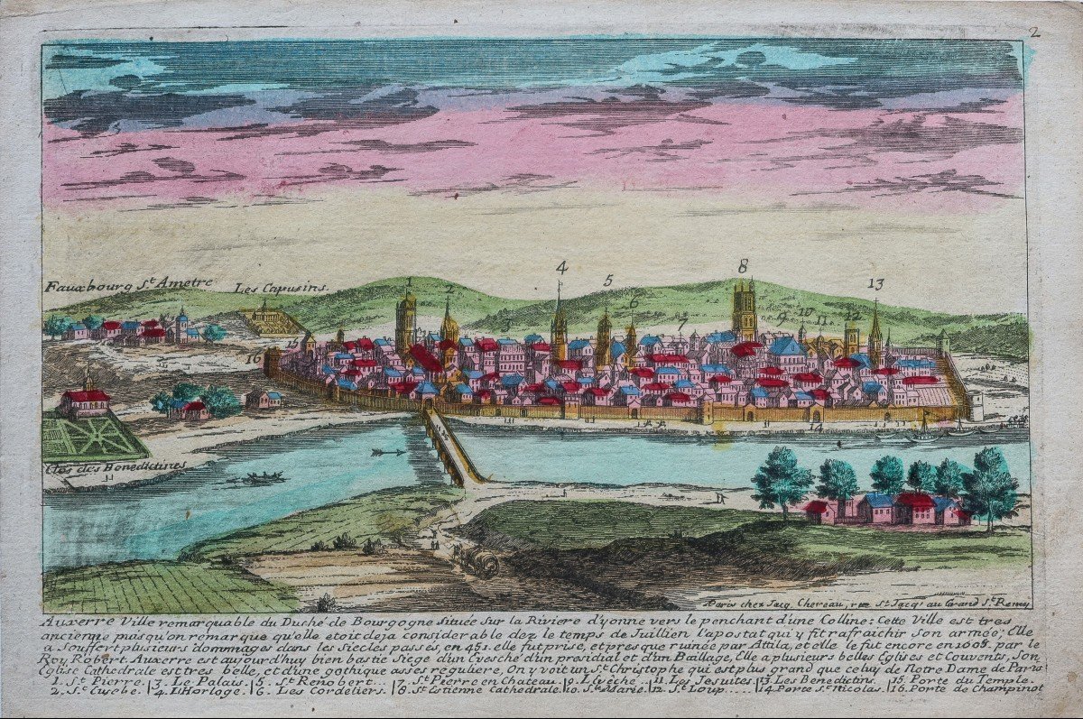
Auxerre ville remarquable du Duché de Bourgogne.
Epreuve originale gravée en 1720. Aveline dessinateur.
Beaux coloris anciens à aquarelle.
Très bon état.
Format feuille : 30,5x 20,5 cm.
Edition peu courante réalisée chez Chereau à Paris.
Renvois dans la marge inférieure de 1 à 15, situant les principaux monuments de la ville.
Vous pouvez consulter l’ensemble des cartes, livres et gravures disponibles sur votre région en cliquant sur le lien de notre site internet spécialisé en archives anciennes géographiques :
https://cartes-livres-anciens.com/categorie-produit/cartes-geographiques-anciennes-original-antique-maps/france/bourgogne-franche-comte/
Règlement sécurisé par carte bancaire sur notre site internet:
https://cartes-livres-anciens.com/produit/cartes-geographiques-anciennes-original-antique-maps/france/bourgogne-franche-comte/gravure-ancienne-de-la-ville-dauxerre/
Toutes nos cartes et gravures sont accompagnées d’un certificat d’authenticité.
Auxerre remarkable city of the Duchy of Burgundy. Original proof engraved in 1720. Aveline designer. Beautiful old watercolor colors. Very good state. Sheet size: 30.5x 20.5 cm. Uncommon edition made at Chereau in Paris. Cross-references in the lower margin from 1 to 15, locating the main monuments of the city. You can consult all the maps, books and engravings available in your region by clicking on the link of our website specializing in ancient geographic archives: https://cartes-livres-anciens.com/categorie-produit/cartes-geographique -anciennes-original-antique-maps / france / bourgogne-franche-comte / Secure payment by credit card on our website: https://cartes-livres-anciens.com/produit/cartes-geographique-anciennes-original-antique -maps / france / bourgogne-franche-comte / old-engraving-of-the-city-dauxerre / All our maps and engravings are accompanied by a certificate of authenticity.
Explore similar pieces and discover your ideal find:
Old Maps