THIS OBJECT WAS SOLD

Map Of The Palace Of Trianon, Watercolor Print, 1705, Golden Frame

Sold
Map Of The Palace Of Trianon, Watercolor Print, 1705, Golden Frame
Sold
Map Of The Palace Of Trianon, Watercolor Print, 1705, Golden Frame-photo-2
Sold
Map Of The Palace Of Trianon, Watercolor Print, 1705, Golden Frame-photo-3
More pictures
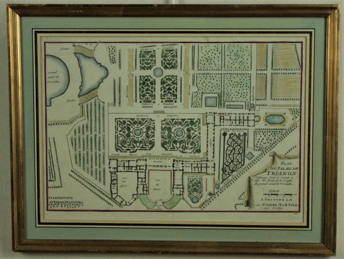
Nicolas de Fer (1646-1720), plan of the palace of Trianon built by Louis the Great at one of the ends of the crossroads of the grand canal of Versailles. watercolor print 24.5 X 34, 5cm, edition in Amsterdam at Pierre Mortier, 1705. gilt wood frame, assembly under mat with decoration of wash and golden net, mounting of the nineteenth century, cardboard background changed and mounted on cardboard museum, outer frame 32.5 X 42.5 cm.

Explore similar pieces and discover your ideal find:

Old Maps

Old Geographical Map Of Venaissin – Avignon
Gravure Originale Du  Caire – View Of Grand Cairo - Salt
Large Dutch Map Of Nieuwe Zee Haven
Old Geographic Map Of Martinique
Saxe - Carte Géographique Ancienne
Old Lithographic Map Guyenne En Gironde Aquitaine Bordeaux Périgord 73x104 Cm

parc de lancosme
Vendoeuvres 36500, France

02 54 38 36 70

06 88 57 47 01

Follow the dealer

CONTACT

SIGN UP TO OUR NEWSLETTER

facebook
instagram

Christophe Vandaele antiquités
Old Lithographic Map Guyenne En Gironde Aquitaine Bordeaux Périgord 73x104 Cm
1310825-main-660991ea5646c.jpg

02 54 38 36 70

06 88 57 47 01


*We will send you a confirmation email from info@proantic.com .
Please check your messages, including the spam folder.