THIS OBJECT WAS SOLD

Optical View

Sold
Optical View
Sold
Optical View-photo-2
Sold
Optical View-photo-3
Sold
Optical View-photo-4
Sold
Optical View-photo-1
More pictures
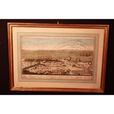
Optical view late 18th century. Perspective view representing "the bombing of the city of Le Havre on July 4, 1749". Publisher: Basset, rue St Jacques. Dimensions of the frame: 62cm x 44.5cm Dimensions of the view: 45.5cm x 27cm Very beautiful scene.

Explore similar pieces and discover your ideal find:

Old Maps
Old Map Of Granville - Normandy
Map Of The City Of Vienna And Its Surroundings
18th Century Map Of France
Geographical Map Of Boulogne – Calais
Orignal Antique Plan  City Of Aix En Provence
Ancient Plan Of Jerusalem

Bois Guillaume 76230, France

06.60.84.78.61

Follow the dealer

CONTACT

SIGN UP TO OUR NEWSLETTER

facebook
instagram

Antiquités l'orangerie
Ancient Plan Of Jerusalem
896922-main-61ffdfacc62cd.jpg

06.60.84.78.61


*We will send you a confirmation email from info@proantic.com .
Please check your messages, including the spam folder.