
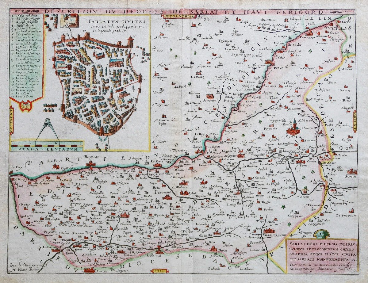

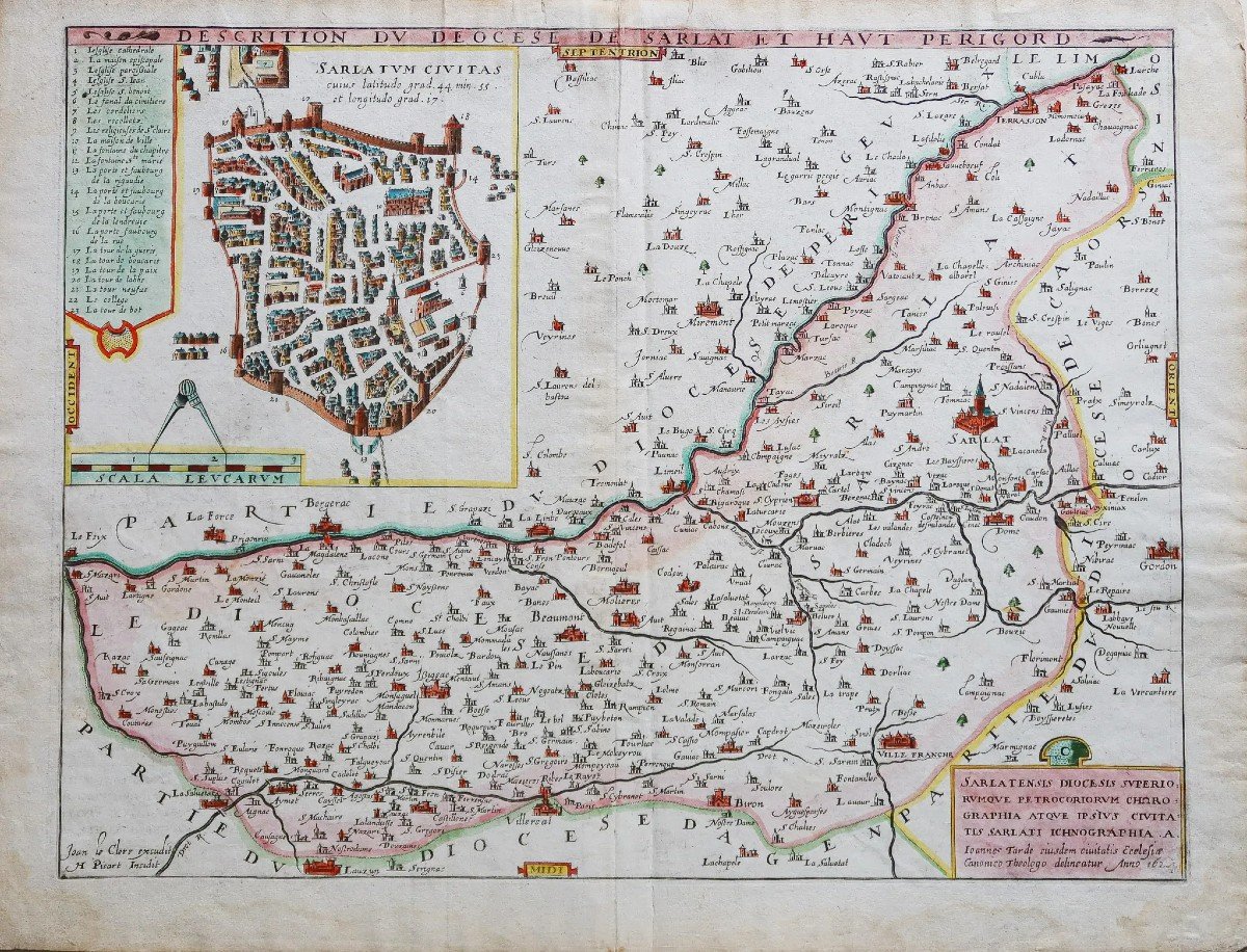
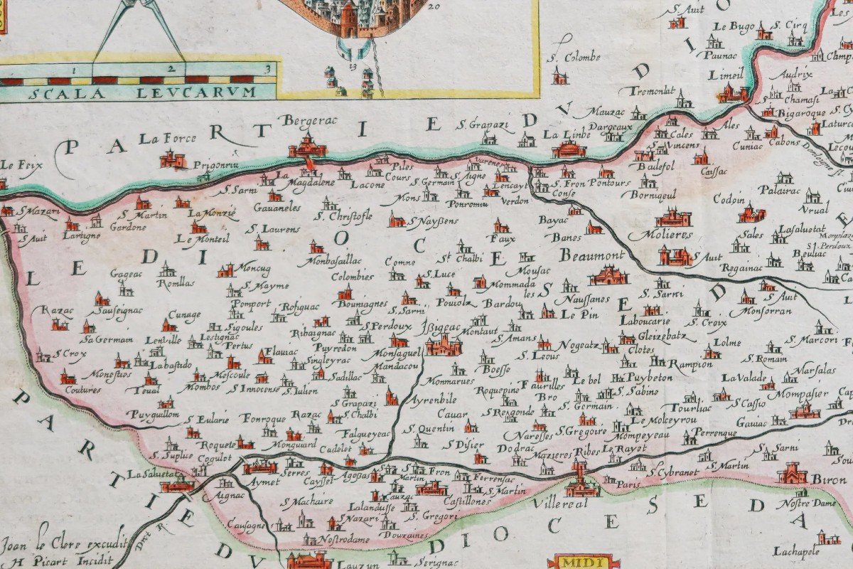


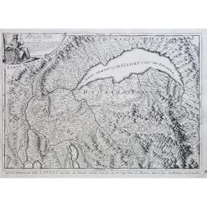
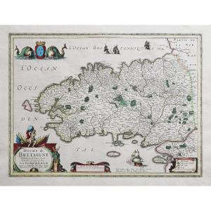
"Old Geographical Map Of The Diocese Of Sarlat – Périgord"
Epreuve originale réalisée en 1624. Leclerc éditeur.Beaux coloris anciens.
Trace de frottement au niveau de la date dans le cartouche inférieur droit.
Rousseurs claires dans les marges, et classique renfort au dos de la marge supérieure.
Bon état.
Format feuille : 53 x 40 cm.
Format gravure : 47 x 36,5 cm.
Original antique map of 1624.
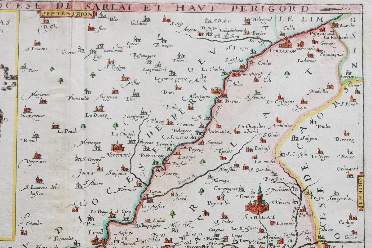
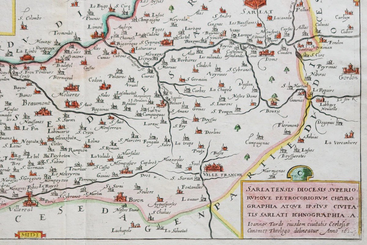
Carte peu courante de cette édition française du 17e siècle par Joan Leclerc. Large cartouche représentant la ville de Sarlat avec renvois de 1 à 23 situant les principaux lieux et monuments.
Echelle des lieux surmontés d’un compas.
Vous pouvez consulter l’ensemble des cartes, livres et gravures disponibles sur votre région en cliquant sur le lien de notre site internet spécialisé en archives anciennes géographiques :
https://cartes-livres-anciens.com/categorie-produit/cartes-geographiques-anciennes-original-antique-maps/france/aquitaine-guyenne-gascogne-perigord/
Règlement sécurisé par carte bancaire sur notre site internet en cliquant sur le lien ci-dessous :
https://cartes-livres-anciens.com/produit/cartes-geographiques-anciennes-original-antique-maps/france/aquitaine-guyenne-gascogne-perigord/carte-geographique-ancienne-du-diocese-de-sarlat-perigord/
Toutes nos cartes et gravures sont accompagnées d’un certificat d’authenticité.
Le CLERC, Imprimeur-libraire, éditeur et graveur d'estampes ; géographe et éditeur de cartes. - Fils de l'imprimeur et éditeur d'estampes parisien Jean III Le Clerc ; frère aîné de l'imprimeur-libraire et éditeur d'estampes David Le Clerc.
Baptisé le 16 août 1560, il est le filleul du graveur parisien François Desprez et du peintre Jérôme Bollery. En activité dès 1587. Entre 1590 et 1594, il est probablement réfugié à Tours, où il travaille pour l'imprimeur-libraire Maurice Bouguereau. Obtient le 20 déc. 1619 un privilège de six ans pour "graver les cartes des provinces de France et les portraits des patriarches et princes du peuple hébreu avec l'histoire chronologique".
Édite, entre autres, des gravures de Jacques Granthomme, Pierre I Firens, Léonard Gaultier et Thomas de Leu. Décédé à Paris en 1621 ou en 1622 ; à cette dernière date sa veuve, Frémine Ricard (ou : Richard), est attestée en sa succession. Son fils Jean V Le Clerc, également graveur et éditeur d'estampes, est reçu libraire dès 1618.
Les cartes de Le Clerc restent rares et sont sans conteste, les premières cartes françaises des régions.
Original proof made in 1624. Leclerc publisher. Beautiful old colors. Trace of friction at the date in the lower right cartridge. Light foxing in the margins, and classic reinforcement on the back of the upper margin. Good condition. Sheet size: 53 x 40 cm. Engraving format: 47 x 36.5 cm. Original antique map of 1624. Uncommon map from this 17th century French edition by Joan Leclerc. Large cartridge representing the town of Sarlat with references from 1 to 23 locating the main places and monuments. Scale of places surmounted by a compass. You can consult all the maps, books and engravings available in your region by clicking on the link to our website specializing in ancient geographical archives: https://cartes-livres-anciens.com/categorie-produit/cartes-gegraphiques -Ancienes-original-antique-maps/france/aquitaine-guyenne-gascogne-perigord/ Secure payment by credit card on our website by clicking on the link below: https://cartes-livres-anciens.com/produit /old-geographic-maps-original-antique-maps/france/aquitaine-guyenne-gascogne-perigord/old-geographic-map-of-the-diocese-of-sarlat-perigord/ All our maps and engravings are accompanied by a certificate of authenticity. Le CLERC, printer-bookseller, publisher and engraver of prints; geographer and map editor. - Son of the Parisian printer and print publisher Jean III Le Clerc; older brother of the printer-bookseller and print publisher David Le Clerc. Baptized on August 16, 1560, he is the godson of the Parisian engraver François Desprez and the painter Jérôme Bollery. Active since 1587. Between 1590 and 1594, he probably took refuge in Tours, where he worked for the printer-bookseller Maurice Bouguereau. Gets Dec 20 1619 a six-year privilege to "engrave maps of the provinces of France and portraits of the patriarchs and princes of the Hebrew people with chronological history". Published, among others, engravings by Jacques Granthomme, Pierre I Firens, Léonard Gaultier and Thomas de Leu. Died in Paris in 1621 or 1622; on the latter date his widow, Frémine Ricard (or: Richard), is certified as his estate. His son Jean V Le Clerc, also an engraver and publisher of prints, became a bookseller in 1618. Le Clerc's maps remain rare and are undoubtedly the first French maps of the regions.


 Le Magazine de PROANTIC
 TRÉSORS Magazine
 Rivista Artiquariato