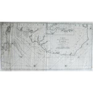


Thames England Map
Map of the entrance to the Thames with benches, passes, Isles and Costes between Sandwich and Clay.
Probably by Le Rouge; middle 18th century
Dimensions: 45.7 x 89 cm 17.99 x 35 inches subject
67 x 98 cm 26.37 x 38.58 inches sheet
The work has been restored by a licensed professional conservator.
All our prints and drawings for sale are in good condition. If necessary, they have been repaired by a licensed professional conservator.
780 €
Period: 18th century
Style: English Style
Condition: Good condition
Material: Paper
Width: 98 cm
Height: 67 cm
Reference (ID): 1159195
Availability: In stock
Print