
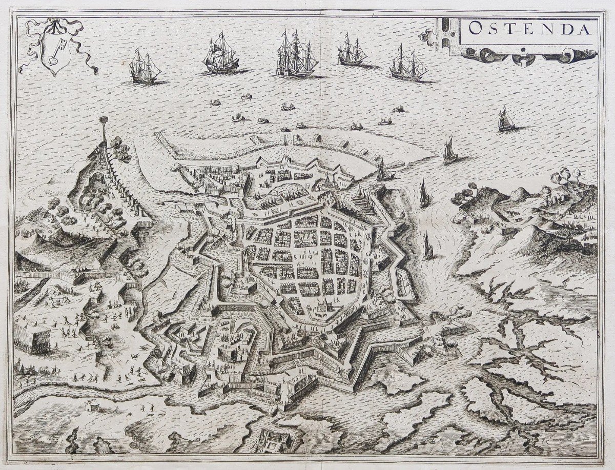
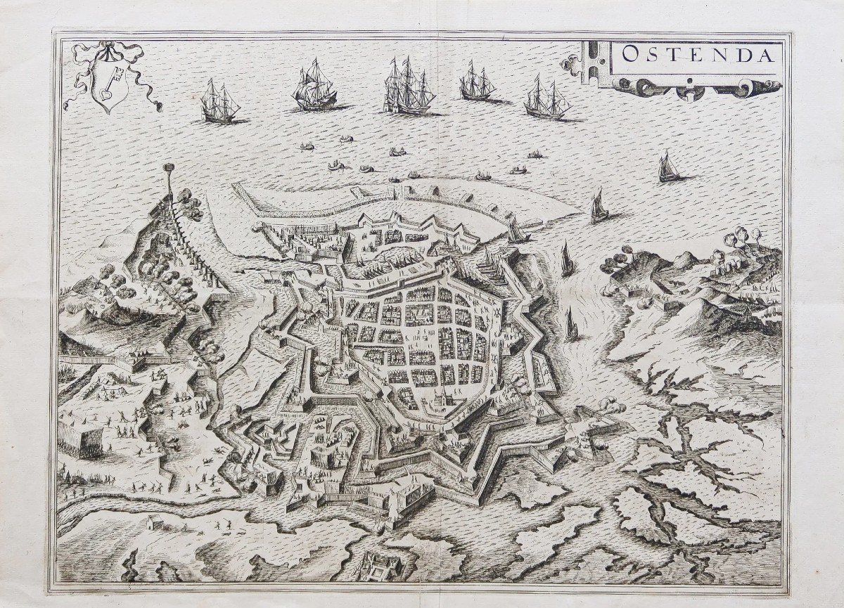


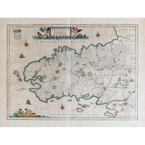
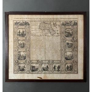
"Old Plan Of The City Of Ostend"
Epreuve originale réalisée en 1590. Braun & Hogenberg cartographes.Belle impression bien contrastée.
Texte explicatif en français au dos.
Très bon état.
Format feuille : 53 x 38,5 cm.
Format gravure : 46,5 x 35,5 cm.
L’une des premières représentations de la ville.
Vous pouvez consulter l’ensemble des cartes et gravures disponibles sur votre région en cliquant sur le lien de notre site internet spécialisé en archives anciennes géographiques :
https://cartes-livres-anciens.com/categorie-produit/cartes-geographiques-anciennes-original-antique-maps/europe/hollande-belgique-luxembourg/
Règlement sécurisé par carte bancaire sur notre site internet en cliquant sur le lien :
https://cartes-livres-anciens.com/produit/cartes-geographiques-anciennes-original-antique-maps/europe/hollande-belgique-luxembourg/plan-ancien-de-la-ville-de-ostende/
Toutes nos cartes et gravures sont accompagnées d’un certificat d’authenticité.
Braun Georg & Franz Hogenberg
Le Civitates Orbis Terrarum de Georg Braun et Frans Hogenberg, collection d’une infinie richesse, est une célébration de la cité européenne. Cette œuvre procure à l’amateur d’aujourd’hui autant de plaisir que lors de sa parution.
L’édition de ces gravures fut répartie sur 45 ans. Elles dépeignent avec force détails, quelques
530 villes d’Europe et d’ailleurs, sous leur aspect d’il y a 400 ans.
L’intérêt de ces vues est considérable, conjuguant les talents d’artistes de premier plan, de graveurs et de cartographes, dans une succession de perspectives horizontales, de plans obliques ou verticaux.
Georg Braun, co-compilateur avec Franz Hogenberg, préférait la vue oblique, car selon lui, « les villes doivent être dessinées de telle façon que l’observateur puisse voir chaque route et chaque rue, ainsi que tous les bâtiments et espaces libres ».
Détails curieux, rarement signalé, les plans et vues du Civitates, dans la majorité des cas, dépeignent une scène relativement sereine, une activité quotidienne et paisible : agriculture, viticulture, pêche, commerce ou tout simplement description de costumes locaux.
Les villes d’Autriche, de Hongrie ou des Pays-Bas espagnols ne font pas exception, alors que pendant la compilation de cette publication, elles furent toutes, à un moment ou à un autre, assourdies par le vacarme de guerres civiles ou internationales.
Il suffit de comparer ces scènes tranquilles avec la description violente des événements de l’époque qu’en donne Hogenberg et d’autres, dans des Geschichtsblätter témoignant des horreurs perpétuées au cours des guerres de religions, dans la lutte pour la libération des Pays-Bas du joug espagnol, à partie de 1561, pour juger du contraste entre ces deux approches.
Il n’est pas surprenant que de nombreux collectionneurs considèrent ces gravures comme la plus précieuse édition du 16ème siècle.
Son responsable d’édition, Georg Braun (1541 – 1622), ecclésiastique à Cologne, où il passa l’essentiel de sa vie, il fut fortement influencé par Ortelius.
On sait peu de chose sur lui, si ce n’est qu’il écrivit divers textes théologiques, aujourd’hui oubliés.
Au cours de la compilation du Civilates, il entretint une correspondance avec les élus des villes, des artistes, ainsi que des cartographes et les graveurs les plus importants de son temps.
On pense également que Braun a rédigé, ou tout du moins supervisé, la plupart des textes imprimés au verso des gravures.
Parmi les graveurs sollicités par Braun, le plus important est sans doute Frans Hogenberg (1535 – 1590), de Malines, en Belgique. Après sa mort, en 1590, nombre de planches furent exécutées par Abraham Hogenberg, son fils présumé.
C’est de son amitié avec Ortelius qui permit à Georg Braun de faire la connaissance d’Hoefnagel (1542 – 1600), artiste d’Anvers.
Celui-ci allait jouer un rôle capital dans l’illustration des gravures. Hoefnagel, issu d’une riche famille, voyagea partout en Europe. Il vécut à Anvers jusqu’en 1576. S’établit ensuite à Cologne et travailla également en Bohème, Bavière et Tyrol en compagnie du cartographe Ortelius.
Le talent d’Hoefnagel reposait sur sa soif de connaissances, et c’est grâce à son observation des détails, qu’il put reproduire les structures de ces cités, ainsi que le mode de vie de leurs habitants.
(John Goss).
Original proof made in 1590. Braun & Hogenberg cartographers. Nice high contrast print. Explanatory text in French on the back. Very good state. Sheet size: 53 x 38.5 cm. Engraving format: 46.5 x 35.5 cm. One of the first representations of the city. You can consult all the maps and engravings available in your region by clicking on the link of our website specializing in ancient geographical archives: https://cartes-livres-anciens.com/categorie-produit/cartes-geographiques-anciennes -original-antique-maps/europe/hollande-belgique-luxembourg/ Secure payment by credit card on our website by clicking on the link: https://cartes-livres-anciens.com/produit/cartes-geographiques-anciennes- original-antique-maps/europe/holland-belgium-luxembourg/old-plan-of-the-city-of-ostende/ All our maps and engravings are accompanied by a certificate of authenticity. Braun Georg & Franz Hogenberg The Civitates Orbis Terrarum by Georg Braun and Frans Hogenberg, an infinitely rich collection, is a celebration of the European city. This work gives today's amateur as much pleasure as when it was first published. The edition of these engravings was spread over 45 years. They depict in great detail some 530 cities in Europe and elsewhere, as they looked 400 years ago. The interest of these views is considerable, combining the talents of leading artists, engravers and cartographers, in a succession of horizontal perspectives, oblique or vertical planes. Georg Braun, co-compiler with Franz Hogenberg, preferred the oblique view, because according to him "cities should be drawn in such a way that the observer can see every road and every street, as well as all buildings and open spaces". Curious details, rarely reported, the plans and views of the Civitates, in the majority of cases, depict a relatively serene scene, a daily and peaceful activity: agriculture, viticulture, fishing, trade or quite simply description of local costumes. The cities of Austria, Hungary or the Spanish Netherlands are no exception, while during the compilation of this publication they were all, at one time or another, deafened by the din of civil or international wars. It is enough to compare these quiet scenes with the violent description of the events of the time given by Hogenberg and others, in Geschichtsblätter bearing witness to the horrors perpetuated during the wars of religion, in the struggle for the liberation of the Bottom of the Spanish yoke, from 1561, to judge the contrast between these two approaches. It is not surprising that many collectors consider these prints to be the most valuable edition of the 16th century. Its editor, Georg Braun (1541 – 1622), an ecclesiastic in Cologne, where he spent most of his life, was strongly influenced by Ortelius. Little is known about him, except that he wrote various theological texts, now forgotten. During the compilation of the Civilates, he maintained a correspondence with the elected officials of the cities, artists, as well as cartographers and the most important engravers of his time. It is also believed that Braun wrote, or at least supervised, most of the texts printed on the back of the engravings. Among the engravers requested by Braun, the most important is undoubtedly Frans Hogenberg (1535 – 1590), from Mechelen, in Belgium. After his death in 1590, many of the plates were executed by Abraham Hogenberg, his presumed son. It was his friendship with Ortelius that allowed Georg Braun to meet Hoefnagel (1542 – 1600), an artist from Antwerp. This was to play a capital role in the illustration of the engravings. Hoefnagel, from a wealthy family, traveled all over Europe. He lived in Antwerp until 1576. Then settled in Cologne and also worked in Bohemia, Bavaria and Tyrol with the cartographer Ortelius. Hoefnagel's talent was based on his thirst for knowledge, and it was thanks to his observation of details that he was able to reproduce the structures of these cities, as well as the way of life of their inhabitants. (John Goss).


 Le Magazine
 Rivista Artiquariato
 TRÉSORS magazine