


"Original Plan Of Paris From The 18th Century – Turgot Michel Etienne"
Plans de Paris dessinés et gravés sous les ordres de Michel Étienne Turgot, prévôt des marchands. Commencé en 1734, achevé de graver en 1739. Levé et dessiné par Louis Bretez, gravé par Claude Lucas.Paris, édition originale de 1739.
1 volume grand in - folio (56 x 45 cm). Plein veau fauve marbré de l’époque, large frise or encadrant les plats, écoinçon, dos à nerfs, caissons ornés de fleurs de lys, toutes tranches dorées.
Les plats sont frappés en leur centre d’un large blason aux Armes de Paris.
Classiques petites restaurations des coins très discrètes.
Bel exemplaire.
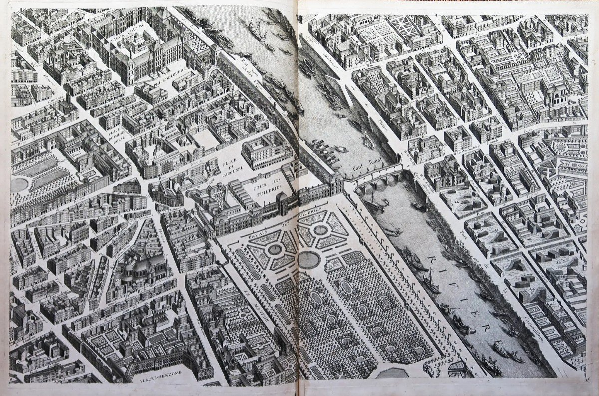
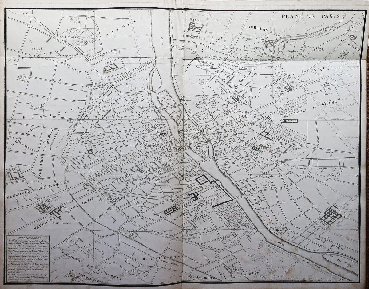
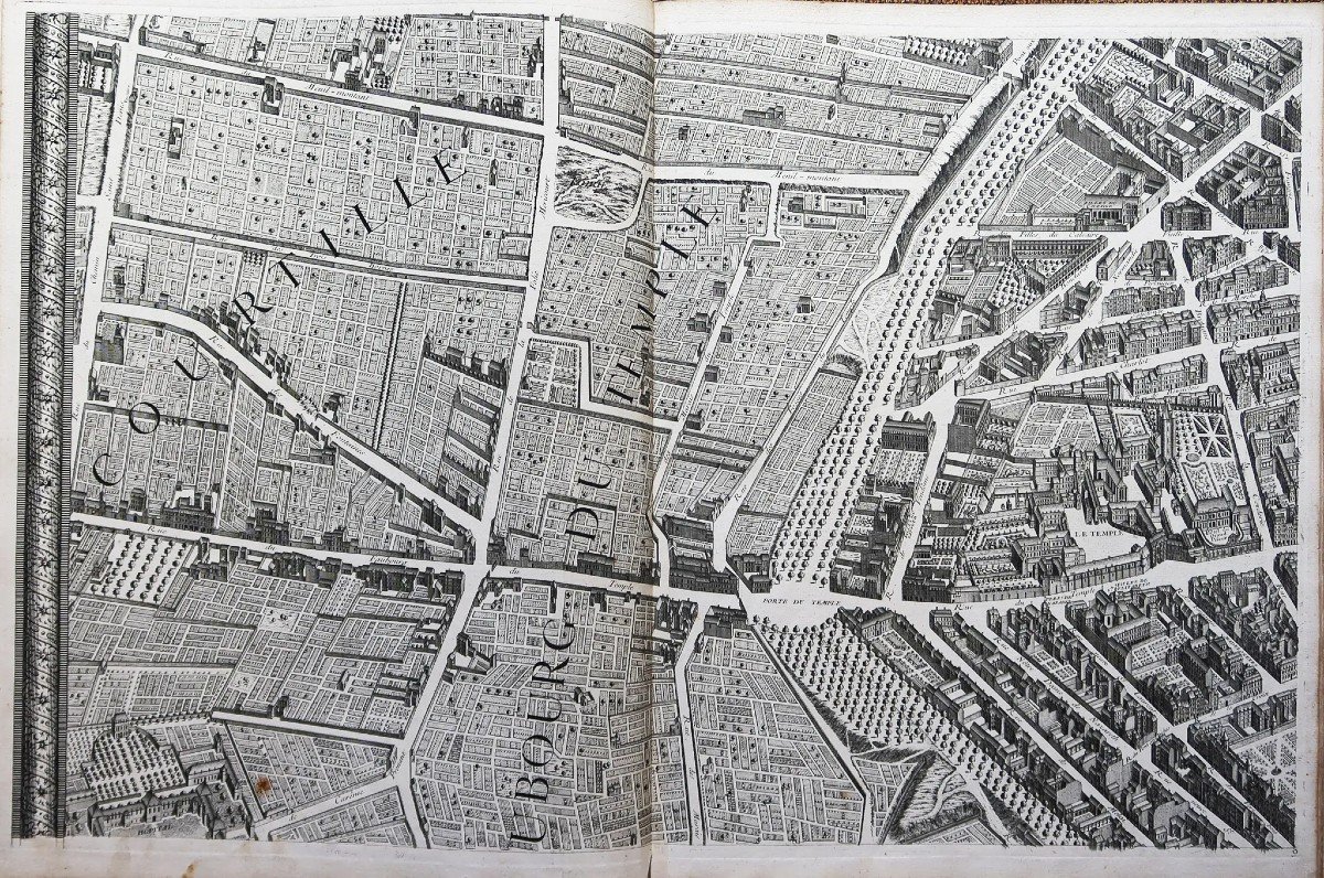
Édition originale composée d'un plan général divisé en 20 sections, facilitant ainsi la consultation des quartiers, suivi de 21 planches sur double page montées sur onglet, d’un format de 80 x 50 cm. Comme d’accoutumé, les planches 18 et 19 sont assemblées. L’ensemble des 21 planches forment un plan de 330 x 260 cm.
Vous pouvez consulter l’ensemble des cartes et gravures disponibles sur votre région en cliquant sur le lien de notre site internet spécialisé en archives anciennes géographiques:
https://cartes-livres-anciens.com/categorie-produit/cartes-geographiques-anciennes-original-antique-maps/france/paris-plans-maps/
Règlement sécurisé par carte bancaire sur notre site internet en cliquant sur le lien:
https://cartes-livres-anciens.com/produit/cartes-geographiques-anciennes-original-antique-maps/france/paris-plans-maps/plan-original-de-paris-turgot/
Toutes nos cartes et gravures sont accompagnées d’un certificat d’authenticité.
En 1734, Michel-Étienne Turgot, alors à la tête de la municipalité parisienne (en tant que prévôt des marchands), décide de promouvoir l’image de Paris auprès des élites (parisiennes, provinciales et étrangères) en faisant réaliser un nouveau plan de Paris. Il confie à Louis Bretez, membre de l’Académie de Peinture et de Sculpture et professeur de perspective, le soin de lever et de dessiner le plan de Paris et de ses faubourgs.Cinq années lui seront nécessaire pour réaliser ce chef d’œuvre.
Maps of Paris drawn and engraved under the orders of Michel Étienne Turgot, Provost of the Merchants. Begun in 1734, finished engraving in 1739. Surveyed and drawn by Louis Bretez, engraved by Claude Lucas. Paris, original edition of 1739. 1 large folio volume (56 x 45 cm). Full contemporary marbled tawny calfskin, large gilt frieze framing the covers, spandrel, ribbed spine, boxes adorned with fleur-de-lis, all edges gilt. The dishes are stamped in their center with a large coat of arms of the Armes de Paris. Classic small restorations of very discreet corners. Nice copy. First edition composed of a general plan divided into 20 sections, thus facilitating consultation of the districts, followed by 21 plates on double page mounted on tabs, in a format of 80 x 50 cm. As usual, boards 18 and 19 are assembled. All 21 boards form a plan of 330 x 260 cm. You can consult all the maps and engravings available in your region by clicking on the link of our website specializing in ancient geographical archives: https://cartes-livres-anciens.com/categorie-produit/cartes-geographiques-anciennes -original-antique-maps/france/paris-plans-maps/ Secure payment by credit card on our website by clicking on the link: https://cartes-livres-anciens.com/produit/cartes-geographiques-anciennes- original-antique-maps/france/paris-plans-maps/original-plan-de-paris-turgot/ All our maps and engravings are accompanied by a certificate of authenticity. In 1734, Michel-Étienne Turgot, then at the head of the Parisian municipality (as provost of the merchants), decided to promote the image of Paris among the elites (Parisians, provincials and foreigners) by having a new plan of Paris. He entrusts Louis Bretez, member of the Academy of Painting and Sculpture and professor of perspective, with the task of surveying and drawing the plan of Paris and its suburbs. Five years will be necessary for him to realize this masterpiece.


 Le Magazine
 Rivista Artiquariato
 TRÉSORS magazine