
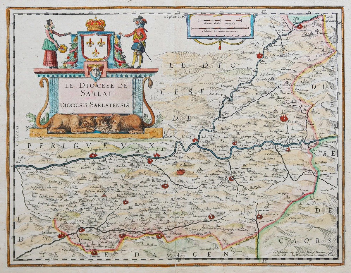
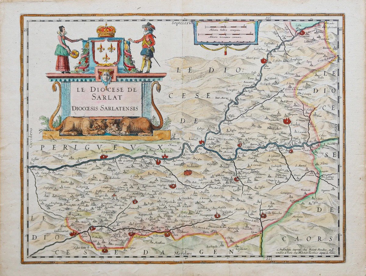
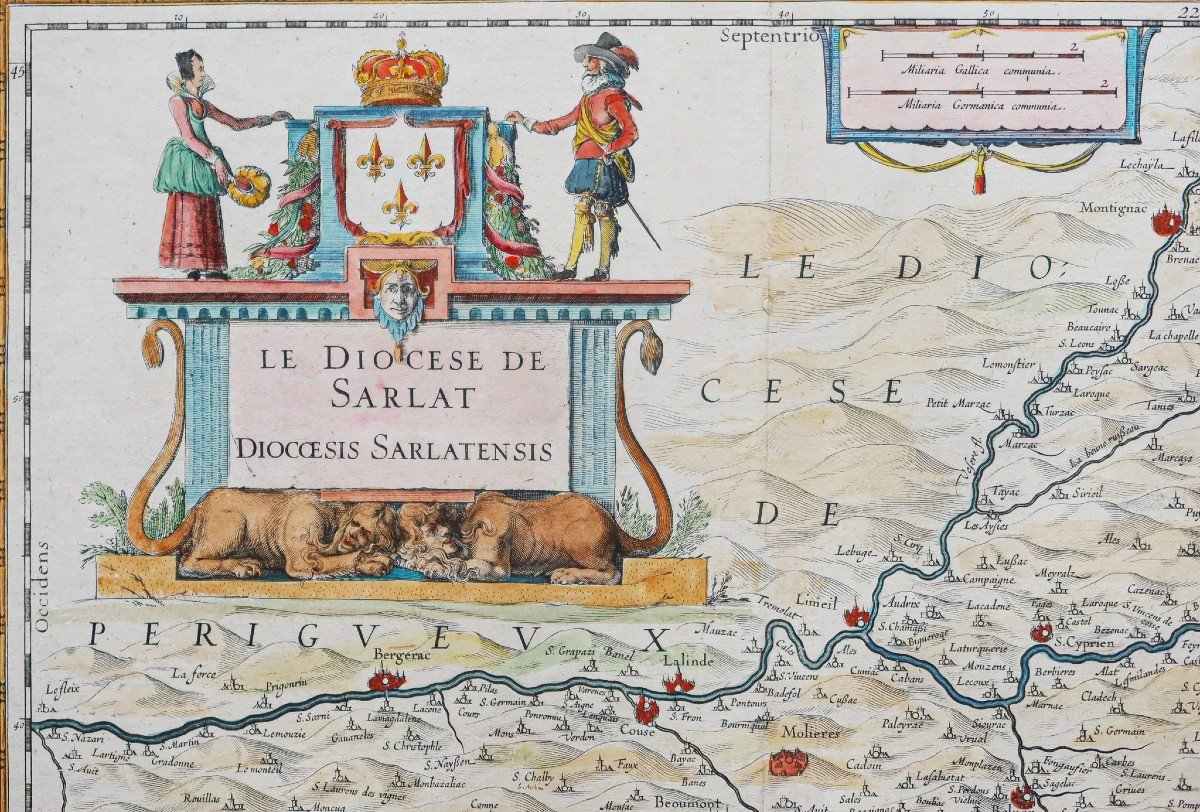
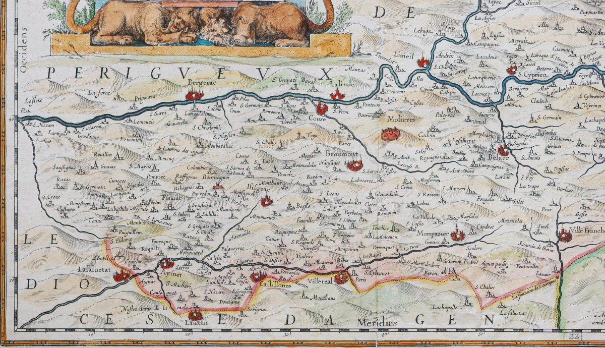
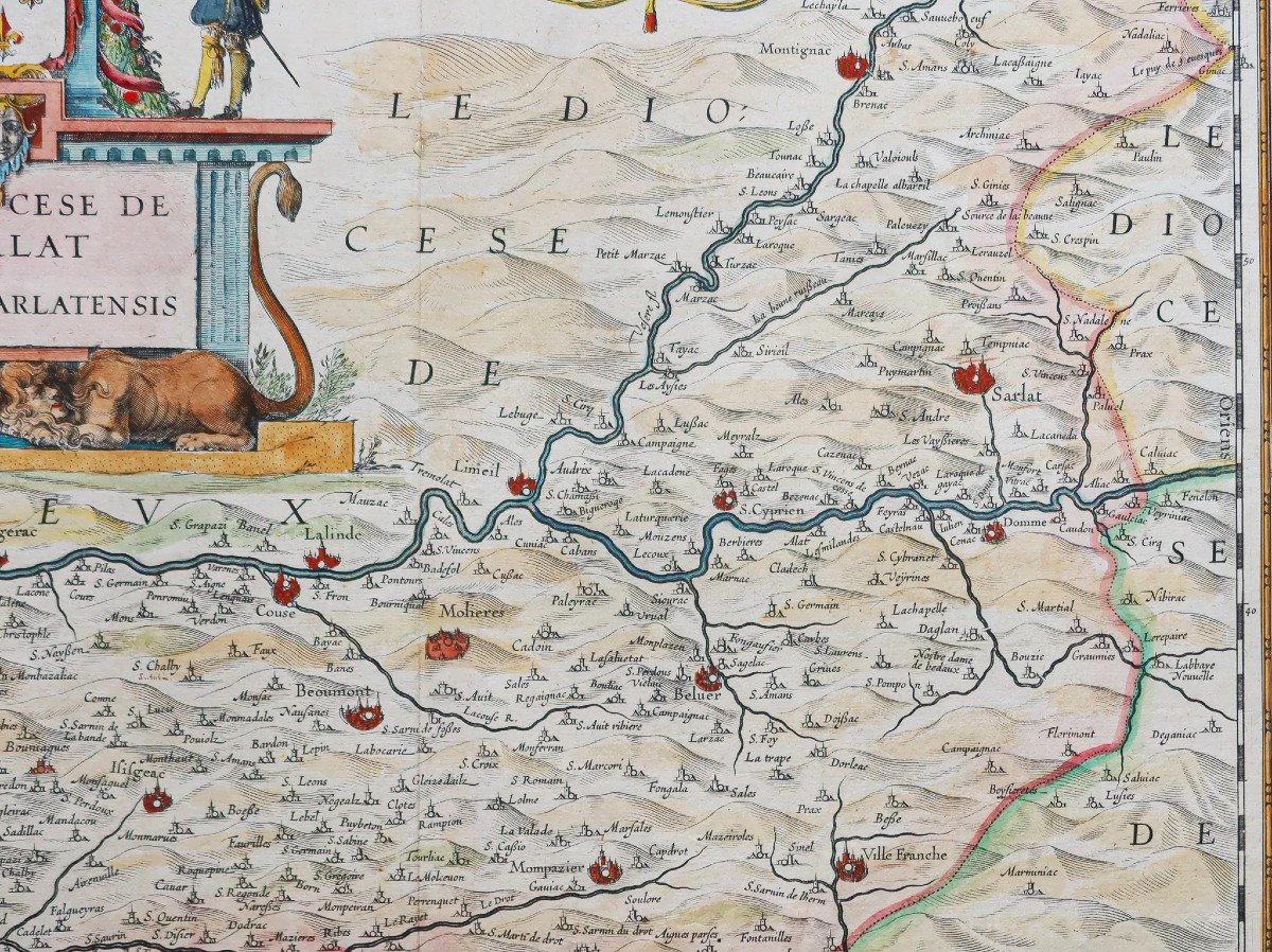


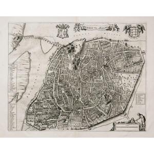
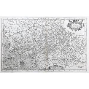
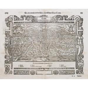
"Old Geographical Map Of The Diocese Of Sarlat"
Epreuve originale réalisée en 1650. Hondius éditeur.Beaux coloris anciens.
Classique renfort de papier au dos de la carte au niveau du pli central dans la marge inférieure.
Bon état.
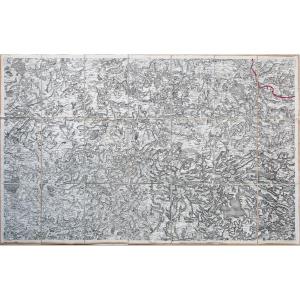
Format feuille: 54,5 x 41,5 cm.
Format gravure: 48 x 37 cm.
Original antique map of 1650.
Somptueux cartouche de titre aux armes de France. Echelle des lieux.
Vous pouvez consulter l’ensemble des cartes, livres et gravures disponibles sur votre région en cliquant sur le lien de notre site internet spécialisé en archives anciennes géographiques:
https://cartes-livres-anciens.com/categorie-produit/cartes-geographiques-anciennes-original-antique-maps/france/aquitaine-guyenne-gascogne-perigord/
Règlement sécurisé par carte bancaire sur notre site internet en cliquant sur le lien ci-dessous:
https://cartes-livres-anciens.com/produit/cartes-geographiques-anciennes-original-antique-maps/france/aquitaine-guyenne-gascogne-perigord/carte-geographique-ancienne-du-diocese-de-sarlat/
Toutes nos cartes et gravures sont accompagnées d’un certificat d’authenticité.
Jodocus Hondius, l’un des graveurs les plus célèbres de son temps, est connu pour son travail en association avec de nombreux cartographes et éditeurs importants à la fin du XVIe et du début du XVIIe siècle.Né en Flandre, il grandit à Gand. Il fut apprenti dans une entreprise de fabrication d’instruments scientifiques, globes et gravure de cartes. En 1584, pour échapper aux troubles religieux qui balayaient les Pays-Bas, il s’enfuit à Londres où il passa quelques années avant de s’installer à Amsterdam vers 1593.
De l’époque londonienne, il conservera les contacts qu’il avait noué avec les plus grands scientifiques et géographes du jour, auteurs de The Mariner’s Mirrour, l’édition anglaise de Waghenaer’s Sea Atlas. Nul ne doute que son exil temporaire à Londres lui fut utile, lui valant une réputation internationale, car ce n’est pas un hasard que John Speed célèbre cartographe anglais, choisit Hondius pour graver les planches des cartes du Théâtre de l’Empire de la Grande-Britaine entre 1605 et 1610.En 1604, Hondius acheta les planches de l’Atlas Mercator qui, malgré son excellence, n’avaient pas réussi à concurrencer la demande persistante des cartes d’Ortelius.
Après la mort de Jodocus Hondius l’Ancien en 1612, ses travaux de cartographie et miniature, ont été confiés à sa veuve et à ses fils, Jodocus II et Henricus, puis à Jan Jansson à Amsterdam. Au total, à partir de 1606, près de 50 éditions comportant un nombre croissant de cartes avec des textes dans les principales langues européennes ont été imprimées.
Original proof produced in 1650. Hondius publisher. Beautiful old colors. Classic paper reinforcement on the back of the card at the level of the central fold in the lower margin. Good condition. Sheet size: 54.5 x 41.5 cm. Engraving format: 48 x 37 cm. Original antique map of 1650. Sumptuous title cartouche with the arms of France. Scale of places. You can consult all the maps, books and engravings available in your region by clicking on the link of our website specializing in ancient geographical archives: https://cartes-livres-anciens.com/categorie-produit/cartes-geographiques -anciens-original-antique-maps/france/aquitaine-guyenne-gascogne-perigord/ Secure payment by credit card on our website by clicking on the link below: https://cartes-livres-anciens.com/produit /cartes-geographiques-anciennes-original-antique-maps/france/aquitaine-guyenne-gascogne-perigord/carte-geographique-ancienne-du-diocese-de-sarlat/ All our maps and engravings are accompanied by a certificate of authenticity. Jodocus Hondius, one of the most famous engravers of his time, is known for his work in association with many important cartographers and publishers in the late 16th and early 17th centuries. Born in Flanders, he grew up in Ghent. He was apprenticed in a company manufacturing scientific instruments, globes and map engraving. In 1584, to escape the religious troubles that were sweeping the Netherlands, he fled to London where he spent a few years before settling in Amsterdam around 1593. From the London period, he kept the contacts he had established with the greatest scientists and geographers of the day, authors of The Mariner's Mirror, the English edition of Waghenaer's Sea Atlas. No one doubts that his temporary exile in London was useful to him, earning him an international reputation, because it is no coincidence that John Speed, a famous English cartographer, chose Hondius to engrave the plates for the maps of the Théâtre de l'Empire de la Britain between 1605 and 1610. In 1604 Hondius purchased the plates of the Atlas Mercator which, despite its excellence, had failed to compete with the persistent demand for Ortelius' maps. After the death of Jodocus Hondius the Elder in 1612, his work of cartography and miniature was entrusted to his widow and his sons, Jodocus II and Henricus, then to Jan Jansson in Amsterdam. In total, from 1606, almost 50 editions featuring an increasing number of maps with texts in the main European languages were printed.


 Le Magazine
 Rivista Artiquariato
 TRÉSORS magazine