
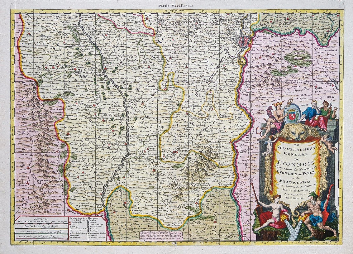


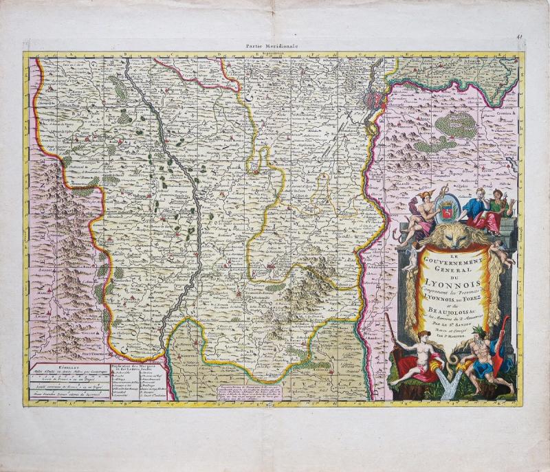

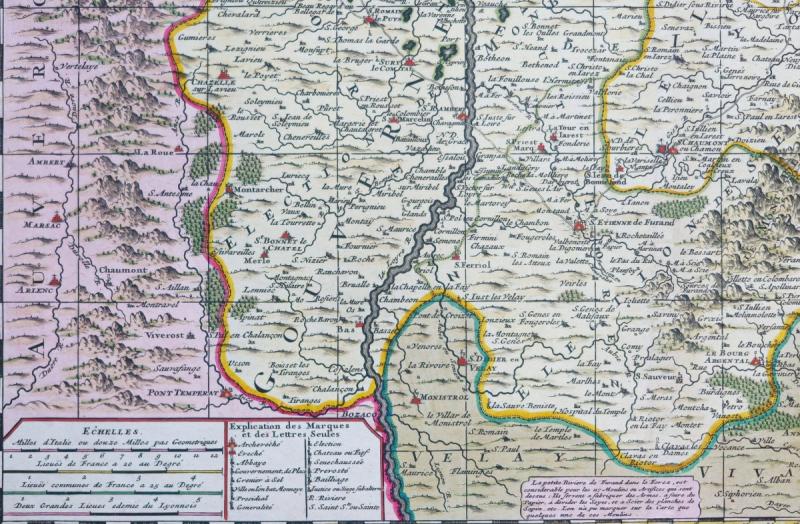
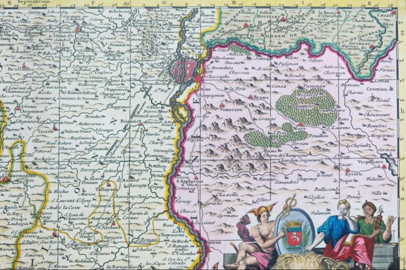

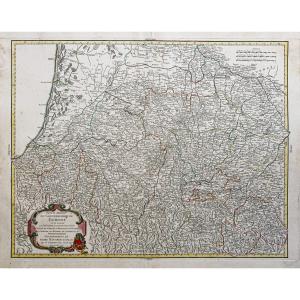
"Old Geographic Map Of Lyonnais Et Forez"
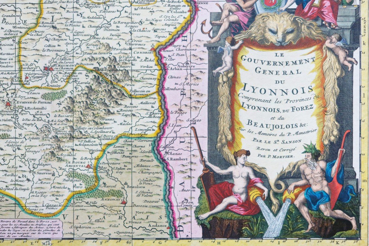
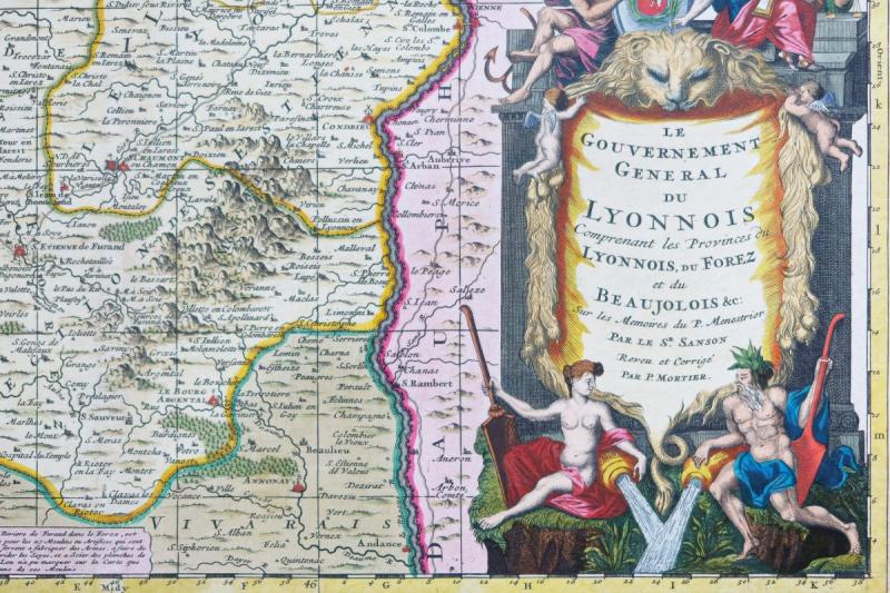
Gouvernement Général du Lyonnois comprenant les Provinces du Lyonnois, du Forez et du Beaujolois &c. sur les mémoires du P. Menestrier.Epreuve originale réalisée en 1770. Pieter Mortier cartographe.
Coloris anciens avec rehauts d’or.
Très bon état.
Format feuille : 62 x 53,5 cm.
Format gravure : 56,5 x 41 cm.
Original antique map of 1770.
Exceptionnels coloris dit «pleins» de l’époque. Large cartouche de titre orné d’un blason et d’attributs illustrant l’abondance de cette région. le titre est surmonté d’une tête de lion soutenue par 2 angelots, le tout avec quelques rehauts de peinture or. Tableaux avec l’explication des marques et échelle des lieux.
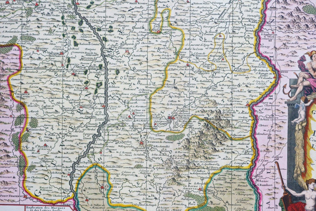
Un encart dans le bas de la carte explique les caractéristiques de la rivière de Furand dans le Forez.
La carte est basée sur les notes de Claude François Ménestrier (1631 - 1705), jésuite français, héraldique et historien, né à Lyon.
Carte réalisée par le cartographe royal Nicolas Sanson et révisée et gravée par Pierre Mortier à Amsterdam.
Vous pouvez consulter l’ensemble des cartes, livres et gravures disponibles sur votre région en cliquant sur le lien de notre site internet spécialisé en archives anciennes géographiques :
https://cartes-livres-anciens.com/categorie-produit/cartes-geographiques-anciennes-original-antique-maps/france/rhone-alpes/
Règlement sécurisé par carte bancaire sur notre site interneten cliquant sur le lien ci-dessous :
https://cartes-livres-anciens.com/produit/cartes-geographiques-anciennes-original-antique-maps/france/rhone-alpes/carte-geographique-ancienne-du-lyonnais-2/
Toutes nos cartes et gravures sont accompagnées d’un certificat d’authenticité.
Pieter et David MORTIERétaient des frères d’origine française dont les publications couvraient un vaste domaine englobant les œuvres françaises et anglaises ainsi que le néerlandais. Pieter a probablement été formé à la vente de livres et de cartes géographiques à Paris et David a passé de nombreuses années en Angleterre; en fait, il acquit la nationalité britannique et mourut vers 1728 environ. Après le décès de Pieter, sa veuve poursuivit ses activités jusqu’à ce que leur fils, Cornelis, soit en mesure de prendre la relève. Puis, en 1721, Cornelis s’associa avec son beau-frère, Johannes Covens, pour former le célèbre nom Covens and Mortier, une entreprise d’exception, réputée pour la qualité des impressions cartographiques.
General Government of Lyonnois comprising the Provinces of Lyonnois, Forez and Beaujolois & c. on the memoirs of Father Menestrier. Original proof made in 1770. Pieter Mortier cartographer. Old colors with gold highlights. Very good state. Sheet size: 62 x 53.5 cm. Engraving format: 56.5 x 41 cm. Original antique map of 1770. Exceptional so-called "full" colors of the time. Large title cartouche decorated with a coat of arms and attributes illustrating the abundance of this region. the title is surmounted by a lion's head supported by 2 cherubs, all with some heightening of gold paint. Tables with explanation of marks and scale of places. An insert at the bottom of the map explains the characteristics of the Furand river in the Forez. The map is based on the notes of Claude François Ménestrier (1631 - 1705), French Jesuit, heraldic and historian, born in Lyon. Map produced by the royal cartographer Nicolas Sanson and revised and engraved by Pierre Mortier in Amsterdam. You can consult all the maps, books and engravings available in your region by clicking on the link of our website specializing in ancient geographic archives: https://cartes-livres-anciens.com/categorie-produit/cartes-geographique -anciennes-original-antique-maps / france / rhone-alpes / Secure payment by credit card on our website by clicking on the link below: https://cartes-livres-anciens.com/produit/cartes-geographique -anciennes-original-antique-maps / france / rhone-alpes / carte-geographique-ancien-du-lyonnais-2 / All our maps and engravings are accompanied by a certificate of authenticity. Pieter and David MORTIER were brothers of French origin whose publications covered a vast field encompassing French and English works as well as Dutch. Pieter was probably trained in selling books and maps in Paris, and David spent many years in England; in fact, he acquired British nationality and died around 1728. After Pieter's death, his widow continued to operate until their son, Cornelis, was able to take over. Then, in 1721, Cornelis joined forces with his brother-in-law, Johannes Covens, to form the famous name Covens and Mortier, an exceptional company renowned for the quality of map prints.


 Le Magazine
 Rivista Artiquariato
 TRÉSORS magazine