
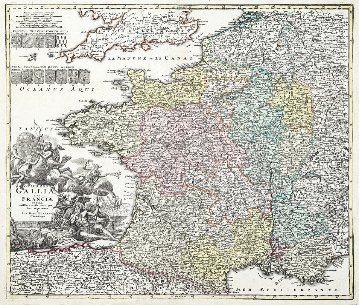
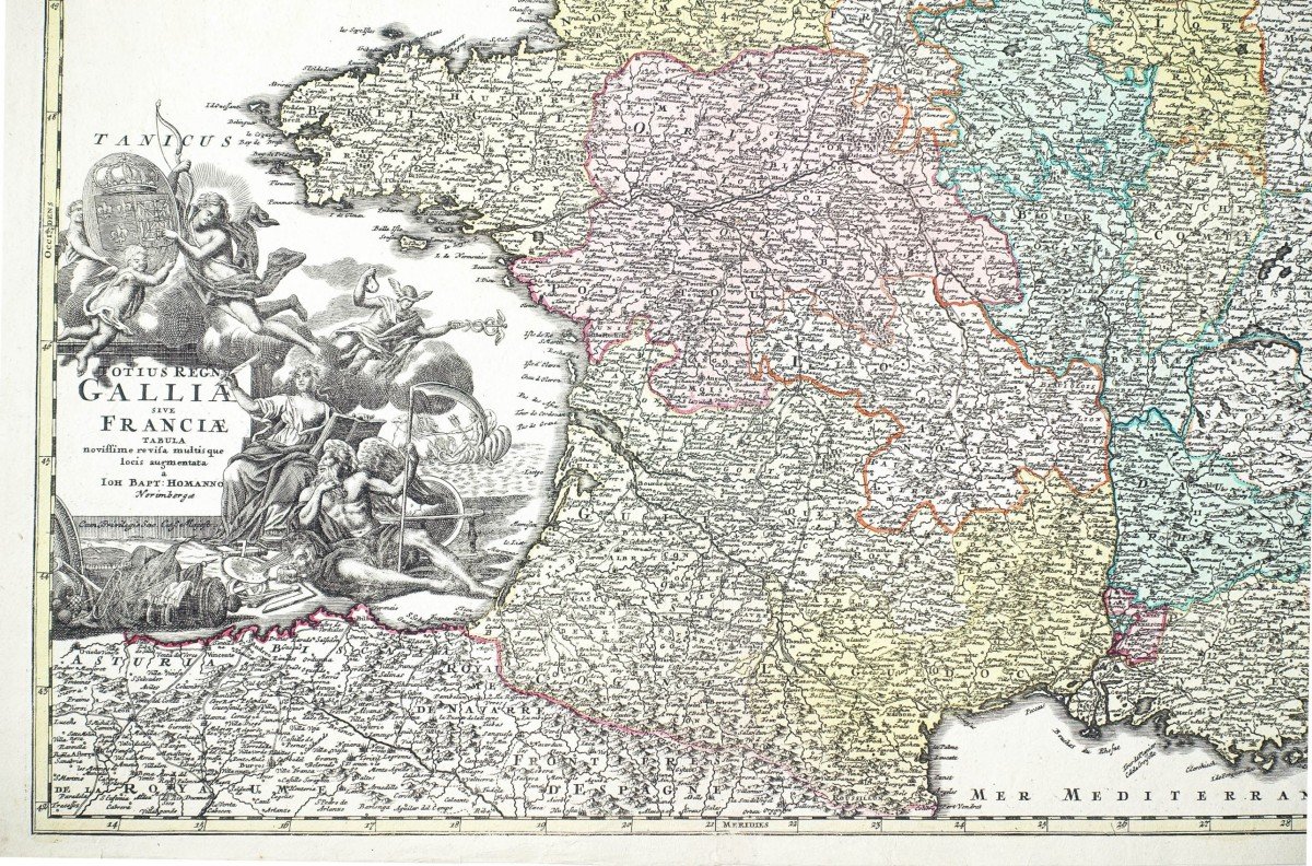
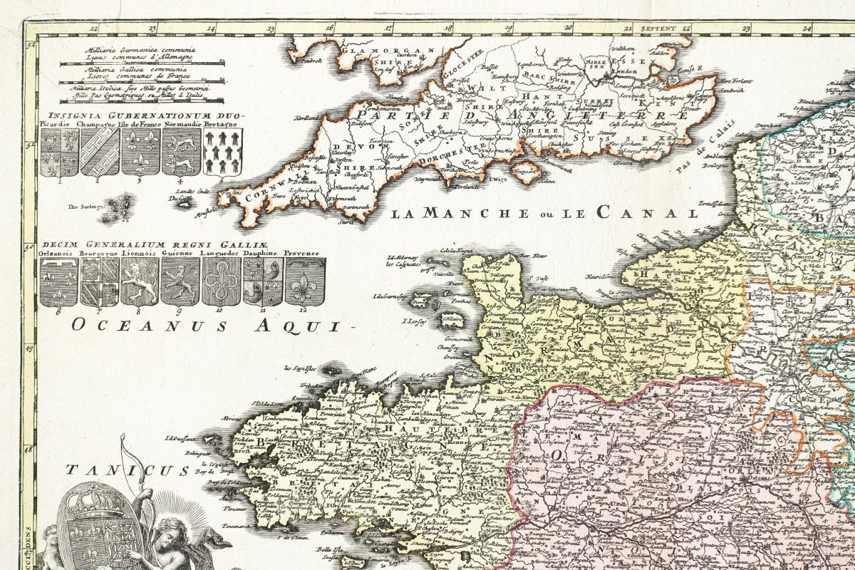
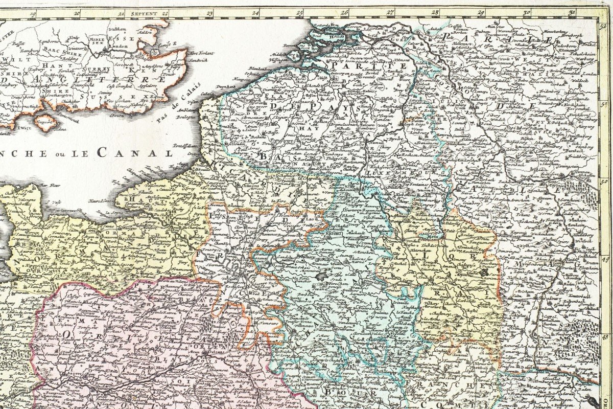


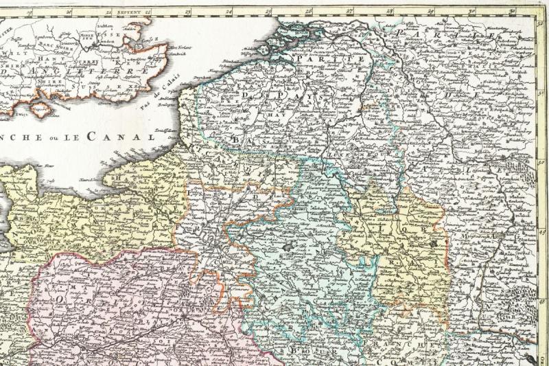
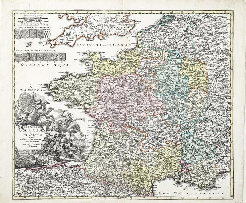
"18th Century Map Of France"
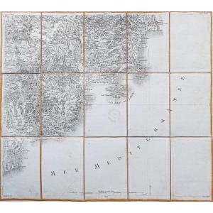
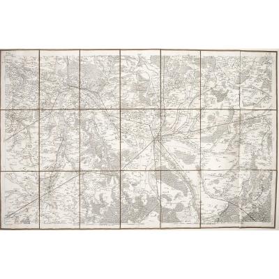
Carte originale gravée en 1729. Jean Baptiste Homann cartographeBeaux coloris anciens.
Petite consolidation ancienne au dos de la marge inférieure.
Très bon état.
Format feuille : 63,5 x 54,5 cm.
Format gravure : 57,5 x 49,5 cm.
Original antique map of 1729.
Carte particulièrement décorative, ornée d’un large cartouche aux Armes de France et blasons gravés des principales régions. Premièreédition avec privilèges.
Vous pouvez consulter l’ensemble des cartes, livres et gravures disponibles sur votre région en cliquant sur le lien de notre site internet spécialisé en archives anciennes géographiques :
https://cartes-livres-anciens.com/categorie-produit/cartes-geographiques-anciennes-original-antique-maps/france/france-generale/
Règlement sécurisé par carte bancaire sur notre site internet:
https://cartes-livres-anciens.com/produit/cartes-geographiques-anciennes-original-antique-maps/france/france-generale/carte-de-france-ancienne-gallia-original-antique-map/
Toutes nos cartes et gravures sont accompagnées d’un certificat d’authenticité.
Johann BaptistHomann(1663-1724), protestant, fonde en 1702 sa propre maison d’édition de cartes et de gravures.
Ses cartes feront de lui, l’un des cartographes allemands les plus renommés; En 1715, il est nommé Géographe Impérial par l’empereur Charles VI.
En 1716, il publiera un ensemble de cartes sous le nom deGrosser Atlasüber die ganze Welt,
« Grand atlas du Monde » . Plusieurs de ces cartes seront réalisées avec la collaboration de graveur Christoph Weigel.
Homann meurt en 1824 à Nuremberg. Sa maison d’édition cartographique, Homann Héritiers, perdurera jusqu’en 1848.
Original map engraved in 1729. Jean Baptiste Homann cartographer Fine old colors. Small old consolidation on the back of the lower margin. Very good state. Sheet size: 63.5 x 54.5 cm. Engraving format: 57.5 x 49.5 cm. Original antique map of 1729. Particularly decorative map, decorated with a large cartouche with the Arms of France and engraved coats of arms of the main regions. First edition with privileges. You can consult all the maps, books and engravings available in your region by clicking on the link of our website specializing in ancient geographic archives: https://cartes-livres-anciens.com/categorie-produit/cartes-geographique -anciennes-original-antique-maps / france / france-generale / Secure payment by credit card on our website: https://cartes-livres-anciens.com/produit/cartes-geographique-anciennes-original-antique-maps / france / france-generale / carte-de-france-ancien-gallia-original-antique-map / All our maps and engravings are accompanied by a certificate of authenticity. Johann Baptist Homann (1663-1724), Protestant, founded in 1702 his own publishing house of maps and engravings. His maps will make him one of the most renowned German cartographers; In 1715, he was appointed Imperial Geographer by Emperor Charles VI. In 1716, he published a set of maps under the name of Grosser Atlasüber die ganze Welt, “Grand atlas du Monde”. Several of these maps will be produced with the collaboration of engraver Christoph Weigel. Homann died in Nuremberg in 1824. His cartographic publishing house, Homann Héritiers, will last until 1848.


 Le Magazine
 Rivista Artiquariato
 TRÉSORS magazine