
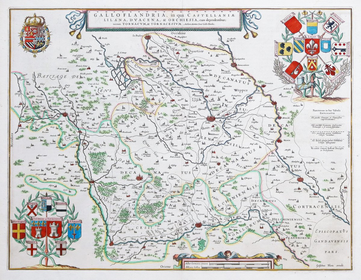


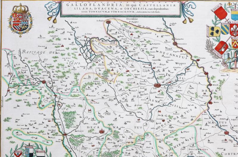

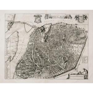
"Old Geographic Map Of The Surroundings Of Lille - North"
Original proof made in 1648. Guilhem Blaeu cartographer.Beautiful watercolor colors.
xplanatory text in Latin on the back.
Excellent condition.
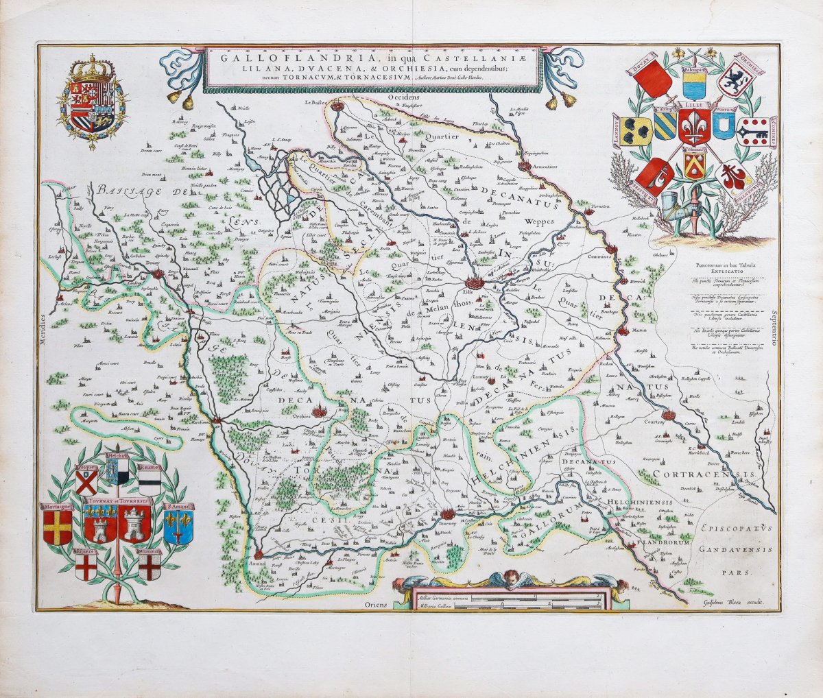
Sheet size: 56 x 48 cm.
Engraving format: 50.5 x 39 cm.
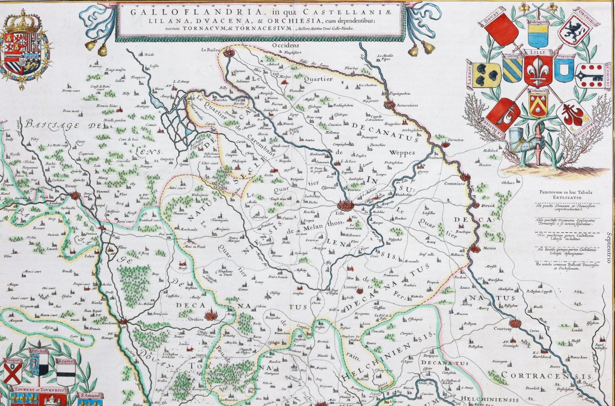
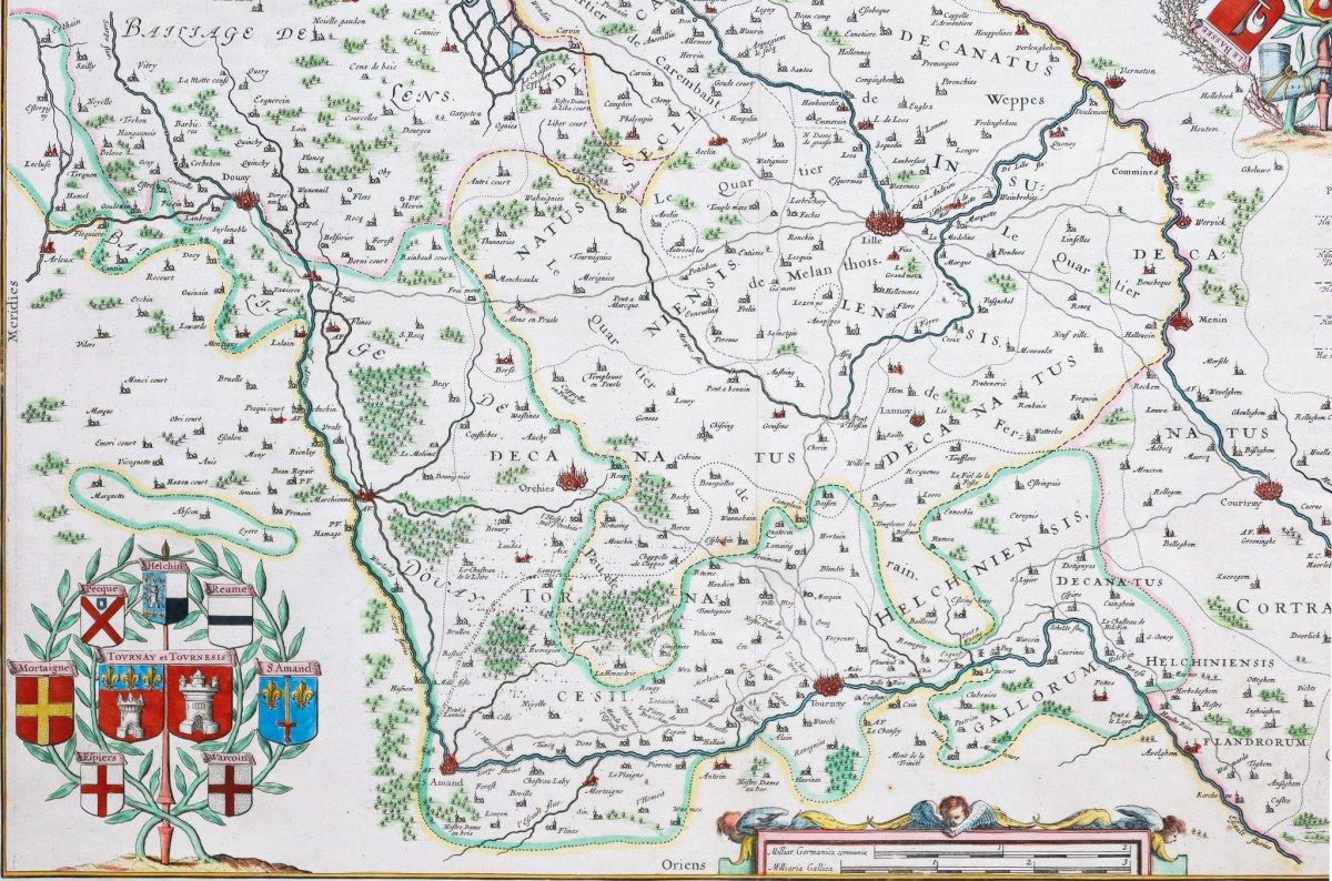
The most beautiful map of the surroundings of Lille published by Blaeu in the 17th century. Particularly decorative, surrounded by the coats of arms of the cities of the periphery.
Martino Doué, geographer, brilliantly illustrates this important city of the great Flanders.
You can consult all the maps, books and engravings available in your region by clicking on the link of our website specializing in ancient geographic archives: https://cartes-livres-anciens.com/categorie-produit/cartes-geographique -anciennes-original-antique-maps / france / nord-pas-de-calais /
Secure payment by credit card on our website: https://cartes-livres-anciens.com/produit/cartes-geographique-anciennes-original -antique-maps / france / nord-pas-de-calais / carte-geographique-ancien-des-surroundings-de-lille-nord /
All our maps and engravings are accompanied by a certificate of authenticity.
At the start of the seventeenth century, Amsterdam was becoming one of the most commercial cities in Europe, the base of the Dutch East India Company, European banking and diamond trading center. Its inhabitants were distinguished by their intellectual skills and their exceptional know-how. In this auspicious period in the history of the northern provinces, Willem Janszoon Blaeu, born in Alkmaar in 1571 is trained in astronomy and science by Tycho Brahe, the famous Danish astronomer who founded a company in Amsterdam in 1599 to manufacture globes and scientific instruments. It didn't take long for the company to expand, publishing maps, topographical works, nautical chart books and globes collections. His most notable early works are a map of Holland (1604), a beautiful map of the world (1605-06) and Het Licht der Zeevaerdt (The light of navigation), a marine atlas. At the same time, Blaeu was preparing a major atlas intended to include the most recent maps of the entire known world, but progress on such a large project remains slow, despite the expensive purchase of 40 brass maps from the edition of Mercator as well as the copper base of the publication of maps of Jodocus Hondius. In 1630, a volume of 60 maps bearing the title Atlantis Annex was published. Five years passed before the publication of the first two volumes of his world atlas, Atlas Novus or the Theatrum Orbis Terrarum. At the same time, Blaeu was appointed hydrographer of the East India Company. In 1638 Blaeu died and the business passed into the hands of his sons, Joan and Cornelis, who continued and expanded their father's ambitious plans. After Cornelis' death Joan ran the business alone and a 6-volume map collection was finally completed around 1655. Preparation for an even larger collection, Atlas Major, came into being and was published in 1662 in 9 volumes. then 11 volumes and finally 12 volumes for the edition with French text. This collection brought together nearly 600 double-page cards and 3000 explanatory texts on the back of the cards. It was and remains the most magnificent work ever of its kind; its geographic content may not have been as up-to-date or as accurate as its author would have liked, but any deficiency in this direction was more than made up for by the finesse of the engravings and their coloring, the elaborate cartouches, the pictorial details and heraldry in particular and the splendid calligraphy. In 1672, a fire destroyed Blaeu's printing house in the Gravenstraat and a year later Joan Blaeu died. The remaining card stocks were gradually dispersed. Some of the print coppers were purchased by cartographers, F. de Wit, Schenk, and Valck, before the final closure around 1695.It should be mentioned here that there is often confusion between the elder Blaeu and his rival Jan Jansson (Johannes Janssonius). Until 1619 Blaeu often signed his works Guilielmus Janssonius or Willems Jans Zoon, but after this period he seems to have opted for Guilielmus or G. Blaeu.
Epreuve originale réalisée en 1648. Guilhem Blaeu cartographe.
Beaux coloris aquarelle.
Texte explicatif en latin au verso.
Excellent état.
Format feuille : 56 x 48 cm.
Format gravure: 50,5 x 39 cm.
La plus belle carte des environs de Lille éditée par Blaeu au 17èmesiècle. Particulièrement décorative, entourée des blasons des villes de la périphérie.
Martino Doué géographe, illustre avec brio cette ville importante des grandes Flandres.
Vous pouvez consulter l’ensemble des cartes, livres et gravures disponibles sur votre région en cliquant sur le lien de notre site internet spécialisé en archives anciennes géographiques :
https://cartes-livres-anciens.com/categorie-produit/cartes-geographiques-anciennes-original-antique-maps/france/nord-pas-de-calais/
Règlement sécurisé par carte bancaire sur notre site internet:
https://cartes-livres-anciens.com/produit/cartes-geographiques-anciennes-original-antique-maps/france/nord-pas-de-calais/carte-geographique-ancienne-des-environs-de-lille-nord/
Toutes nos cartes et gravures sont accompagnées d’un certificat d’authenticité.
Au début du dix-septième siècle, Amsterdam est en train de devenir l’une des villes les plus commerçantes d’Europe, base de la Compagnie néerlandaise des Indes orientales, centre bancaire européen et du commerce du diamant. Ses habitants se distinguaient par leurs compétences intellectuelles et leur savoir-faire exceptionnel.
En cette période propice de l’histoire des provinces du Nord,Willem Janszoon Blaeu, né à Alkmaar en 1571 est formé à l’astronomie et aux sciences par Tycho Brahe, le célèbre astronome danois qui fonda une entreprise à Amsterdam en 1599 de fabrication de globes et d’instruments scientifiques. L’entreprise ne tarde pas à prendre de l’expansion, publiant des cartes, des ouvrages topographiques, des livres de cartes marines et des collections de globes. Ses premiers travaux les plus remarquables sont une carte de la Hollande (1604), une belle carte du monde (1605-06) et Het Licht der Zeevaerdt (La lumière de la navigation), un atlas marin.
Au même moment, Blaeu préparait un atlas majeur destiné à inclure les cartes les plus récentes de l’ensemble du monde connu, mais la progression d’un si vaste projet reste lente, malgré l’achat onéreux de 40 cuivres de cartes de l’édition de Mercator ainsi que le fond de cuivre de la publication de cartes de Jodocus Hondius. En 1630, un volume de 60 cartes portant le titre Atlantis Annex fut publié. Cinq années se sont écoulées avant la publication des deux premiers volumes de son atlas mondial, Atlas Novus ou le Theatrum Orbis Terrarum. À la même époque, Blaeu fut nommé hydrographe de la Compagnie des Indes orientales.
En 1638, Blaeu mourut et l’entreprise passa aux mains de ses fils, Joan et Cornelis, qui poursuivirent et élargirent les ambitieux projets de leur père. Après la mort de Cornelis, Joan dirigea l’entreprise seul et une collection de cartes en 6 volumes fut finalement achevée vers 1655. La préparation d’une collection encore plus grande, Atlas Major, vit le jour et fut publié en 1662 en 9 volumes puis 11 volumes et enfin 12 volumes pour l’édition avec texte français. Cette collection réunissait près de 600 cartes double page et 3000 textes explicatifs au verso des cartes. C’était et reste l’œuvre la plus magnifique jamais réalisée en son genre; son contenu géographique n’était peut-être pas aussi à jour ni aussi exact que son auteur l’aurait souhaité, mais toute carence dans cette direction était plus que compensée par la finesse des gravures et leurs coloration, les cartouches élaborés, les détails picturaux et héraldiques en particulier et la splendide calligraphie. En 1672, un incendie détruisit l’imprimerie de Blaeu dans la Gravenstraat et un an après, Joan Blaeu décéda. Les stocks de cartes restants furent progressivement dispersés. Certains des cuivres d’impression ont été achetés par les cartographes, F. de Wit, Schenk et Valck, avant la fermeture définitive vers 1695.Il convient de mentionner ici qu’il existe souvent une confusion entre l’aîné Blaeu et son rival Jan Jansson (Johannes Janssonius). Jusqu’en 1619, Blaeu signa souvent ses œuvres Guilielmus Janssonius ou Willems Jans Zoon, mais après cette période, il semble avoir opté pour Guilielmus ou G. Blaeu.


 Le Magazine
 Rivista Artiquariato
 TRÉSORS magazine