
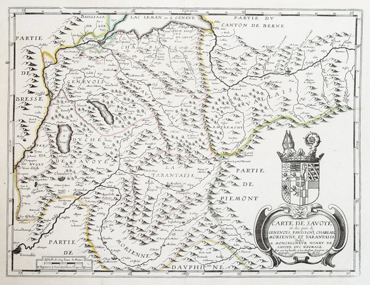

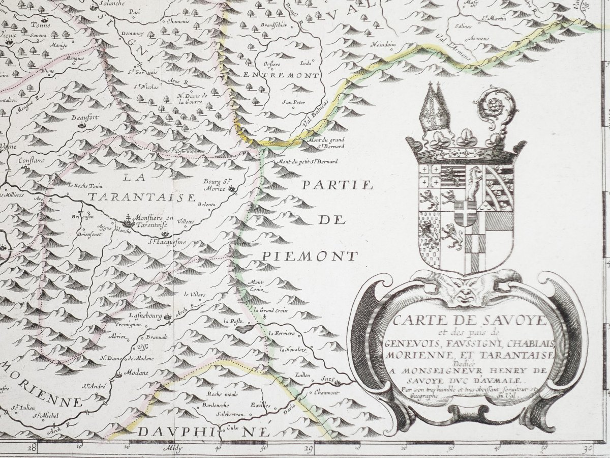

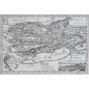
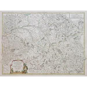
"Antique Geographical Map Of Savoie"
Original proof engraved around 1660. Pierre Duval cartographer. Colored boundaries of the time. Tiny freckle in the left side margin away from the map. Very good state. Sheet size: 54.5 x 43 cm. Engraving format: 48 x 36.5 cm. Original antique map around 1660. Uncommon map in French edition from the beginning of the 17th century. Elegant layout, large title block for regional coats of arms, scale of measurements. You can consult all the maps and engravings available in your region by clicking on the link of our website specializing in old geographic archives: https: //www.cartes-livres-anciens.com Secure payment by credit card on our site internet: https://cartes-livres-anciens.com/produit/cartes-geographique-anciennes-original-antique-maps/europe/italie/carte-geographique-ancienne-de-savoie-genevois/ Pierre Duval (1618-1683 ) was a French geographer, cartographer and publisher who worked in Abbeville and Paris in the 17th century. Nephew of the famous cartographer Nicolas Sanson, from whom he learned the art and skills of the cartographer, the 2 men then worked at the royal court, following the King's request to bring together the crafts in Paris. He made many new maps and atlases. He was appointed “Ordinary Geographer of the King” from 1650 and died in 1683. His wife and daughters continued his activity after his death.Epreuve originale gravée vers 1660. Pierre Duval cartographe.
Limites colorées de l’époque.
Infime rousseur dans la marge latérale gauche loin de la carte.
Très bon état.
Format feuille : 54,5 x 43 cm.
Format gravure : 48 x 36,5 cm.
Original antique map around 1660.
Carte peu courante en édition française du début du 17èmesiècle.Élégantemise en page, large cartouche de titre des blasons régionaux, échelle des mesures.
Vous pouvez consulter l’ensemble des cartes et gravures disponibles sur votre région en cliquant sur le lien de notre site internet spécialisé en archives anciennes géographiques :https://www.cartes-livres-anciens.com
Règlement sécurisé par carte bancaire sur notre site internet: https://cartes-livres-anciens.com/produit/cartes-geographiques-anciennes-original-antique-maps/europe/italie/carte-geographique-ancienne-de-savoie-genevois/
Pierre Duval (1618-1683) était un géographe, cartographe et éditeur français qui a travaillé à Abbeville et à Paris au XVIIe siècle.
Neveu du célèbre cartographe Nicolas Sanson, de qui il apprit l’art et les compétences du cartographe, les 2 hommes travaillèrent ensuite à la cour royale, suite à la demande du Roi de rassembler les métiers d’art à Paris.
Il réalisa de nombreuses nouvelles cartes et atlas.
Il fut nommé «géographe ordinaire du Roi» àpartir de 1650 et décède en 1683.
Sa femme et ses filles continuèrent son activité après sa mort.


 Le Magazine
 Rivista Artiquariato
 TRÉSORS magazine