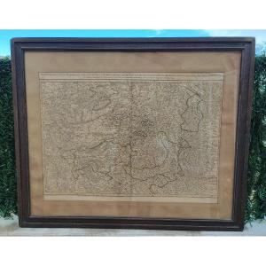
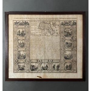
MAP from 1699: “Southern part of the Temporel of the Bishopric of METZ, and parts of the Bailiwicks of NANCY and Allemand, in the Duchy of LORRAINE, divided by Châtellenies, Offices, Provosts, the adj[...]
Epreuve originale réalisée en 1571. Abraham Ortelius cartographe.
Coloris anciens.
Marge latérale droite rapportée anciennement.
Texte en vieux néerlandais au verso.
Tâches anciennes dans le bas d[...]
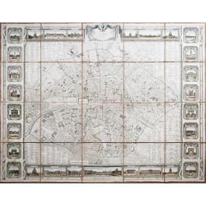
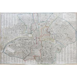
Plan de la ville et faubourgs de Paris avec ses monuments, divisé par quartiers et arrondissements.
Epreuve originale réalisée en 1815. J. Bonnisel géographe.
48 sections entoilées d’époque.
Rousse[...]
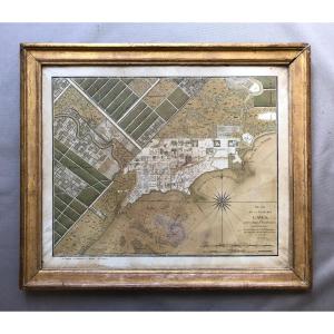
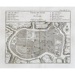
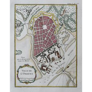
Map of the City of Les Cayes in Isle St. Domingue.
Published by René Phelipeau in 1786.
Watercolor engraving, framed and under glass.
Period frame gilded with leaf.
Moisture stains and small tears[...]
Lithographie originale de 1870. Benoist dessinateur et lithographe.
Belle impression en couleurs.
Fines rousseurs du temps.
Très bon état.
Format feuille : 46 x 31 cm.
Vous pouvez consulter l’e[...]
Epreuve originale réalisée en 1598. Abraham Ortelius cartographe.
Un pli ancien dans l’angle supérieur droit.
Texte en vieux français au verso.
1 petit trou de ver dans l’Andalousie.
Bon état.
Fo[...]
Epreuve originale réalisée en 1764. Bellin géographe.
Coloris aquarelle.
Rousseurs claires dans les marges.
Très bon état.
Format feuille : 34 x 24,5 cm.
Format gravure : 23 x 18 cm.
Original an[...]
This map is from the 18th century, no doubt about it. It is beautifully made. Unfortunately, we report numerous traces of humidity and spots of freckles, the card is a little warped at the bottom, a s[...]
Epreuve originale réalisée en 1760. Bellin géographe.
Coloris aquarelle.
Rousseurs claires dans les marges.
Très bon état.
Format feuille : 48 x 34 cm.
Format gravure : 24 x 18 cm.
Original anti[...]
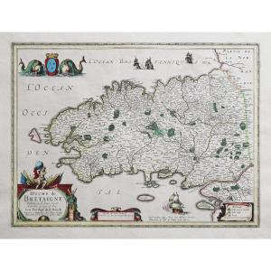
LA GUYENNE.
Large black and white lithographic map. Representation of this region of Gironde (Aquitaine), close to Bordeaux.
Period at the very end of the 19th century / beginning of the 20th centur[...]
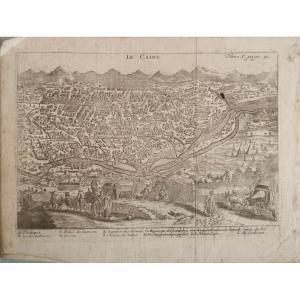
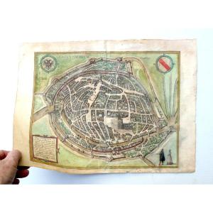
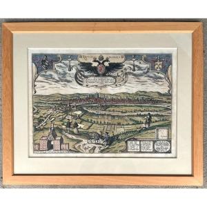
Plan of the city of Metz in 1572, taken from the book "Civitates Orbis Terrarum", and including 564 perspective views of the main cities of the world. The plan is framed in a pitch pine frame with ebo[...]
Epreuve originale réalisée en 1648. Blaeu éditeur.
Coloris aquarelle.
Fine trace de pli au niveau du pli central.
Texte en gothique au verso.
Bon état.
Format feuille : 60,5 x 50 cm.
Format grav[...]
"France SINCE ITS ENLARGEMENT BY THE ROYAL CONQUEST". By DUVAL, Her Majesty's Geographer. Original engraving on steel with a burin and laid paper. Hand watercolored. This series is very RARE, the card[...]
Epreuve originale réalisée en 1760. Bellin géographe.
Coloris aquarelle.
Rousseurs claires dans les marges.
Très bon état.
Format feuille : 47,5 x 34 cm.
Format gravure : 37 x 23 cm.
Original an[...]
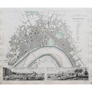
Road map of the city and suburbs of Paris divided into 12 town halls. Original proof made in 1815. Colored limits of the time. Some reinforcements on the back of the card at the folds. Scattered fre[...]
Epreuve originale réalisée en 1760. Bellin géographe.
Coloris aquarelle.
Rousseurs claires dans les marges.
Très bon état.
Format feuille : 33,5 x 24 cm.
Format gravure : 23 x 19 cm.
Original an[...]
Epreuve originale réalisée en 1760. Bellin géographe.
Coloris aquarelle.
Rousseurs claires dans les marges.
Très bon état.
Format feuille : 47,5 x 34 cm.
Format gravure : 35 x 23,5 cm.
Original [...]
BOWLES (Carrington) Bowles's draught of the river Thames, from it's spring in Gloucestershire, to it's influx into the sea [Map of the Thames from Gloucester to the Isle of Thanet] Second revised edit[...]
Epreuve originale réalisée en 1692. Rossi Domenico et Giacomo Cantelli auteurs.
Très belle épreuve sur papier fort.
Très bon état.
Format feuille : 62,5 x 47 cm.
Format gravure : 59 x 45,5 cm.
Or[...]
Huge 18th Century Map (1730) Of The Pyrenees Mountains And Part Of The Kingdoms Of France & Spain By Antoine Coquart (16..-17..) and Roussel (king's engineer, 16..-1733) Canvased at the Bel period con[...]
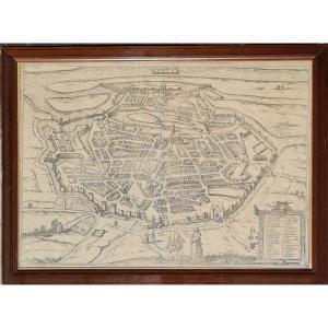
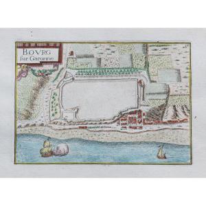
One of the oldest known plans of La Rochelle (1570) in its original state, not watercolored, Gothic text on the reverse. An original median fold, old repair on the upper margin, dirt. Beautiful docume[...]
État : Excellent, la feuille a été doublée, ce qui la rendu solide. Les couleurs d’époque sont fraîches.
(Pour le texte suivant, je me suis largement inspiré d’une traduction d’un texte de Curtis Wri[...]
Due to the famous designer and cartographer Frans Hogenberg (1535-1590), published in famous 1584 work of Georg Braun (1541-1622), this copper engraving, perhaps not colored at period? engraved bowl: [...]
2 grandes épreuves originales réalisées vers 1680. Coronelli auteur.
Rousseurs claires n’affectant pas la carte.
Très bon état.
Format de chaque feuille : 73 x 49,5 cm.
Format assemblée : 146 cm x[...]
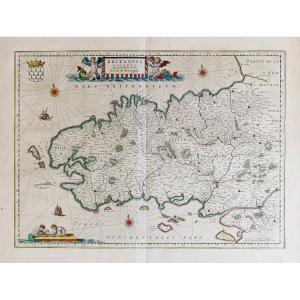
Epreuve originale réalisée en 1634. Blaeu cartographe.
Coloris anciens.
Texte explicatif en latin au verso.
1 oxydation prononcée sur 5mm dans le cartouche de titre.
Bon état.
Format feuille : 59[...]
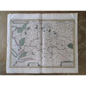
Very beautiful map of the Pais de Xaintonge, watercolor map, in good condition, presence of tape on the border, Map of the Pais de Xaintonge, Amstelodami Excusum apud Iudocum et Henricum Hondium. Arou[...]
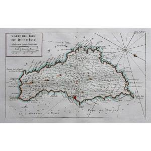
Epreuve originale réalisée en 1630. Hondius cartographe.
Fine restauration et léger frottement au-dessus de Belle-Île.
Coloris aquarelle.
Bon état.
Format feuille : 57 x 49 cm.
Format gravure : 5[...]
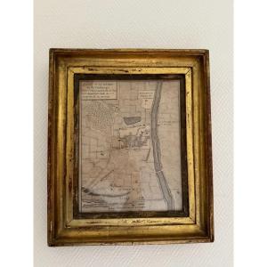
Old map of the city of Auxerre in its gilded wooden frame, 18th century period Writing in old French Frame size 24 by 29 cm Beautiful patina, full of charm Find us on antiquites-monfuturanterieur.fr a[...]
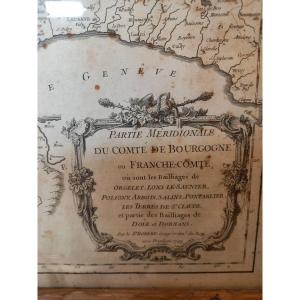
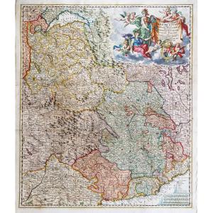
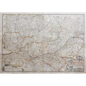
Large map of Franche-Comté drawn up in 1695 by Jaillot Géographe du Roi, and dedicated to the Dauphin. Interesting topographical and administrative document showing the monarchy's desire to methodical[...]
Large map dated 1749 drawn up by Mr. Robert, ordinary geographer of the King, representing in two sheets in folio assembled in a frame Franche-Comté and its various bailiwicks. Interesting topographic[...]
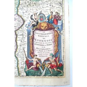
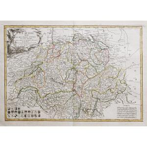
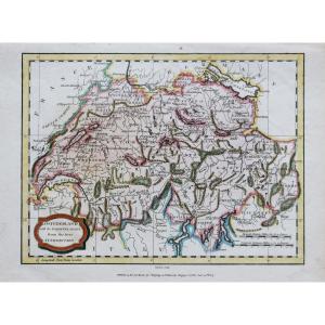
Divisée en ses 13 cantons et ses alliés.
Epreuve originale réalisée en 1782. Bonne cartographe.
Limites colorées à l’aquarelle.
Petits trous de ver près de Zurich. Restauration ancienne dans la mar[...]
Epreuve originale réalisée en 1638. Tassin géographe.
Coloris aquarelle.
2 petits trous de ver dans la marge supérieure loin du sujet.
Bon état.
Format feuille : 23 x 17 cm.
Format gravure : 15 x[...]
Epreuve originale réalisée en 1832. J. Henshall graveur et Clarke dessinateur.
Fine consolidation dans la marge latérale droite n’atteignant pas la carte.
Bon état.
Format feuille : 41 x 34,5 cm.
[...]
Epreuve originale réalisée en 1705. Nicolas de Fer géographe.
Beaux coloris aquarelle.
Très bon état.
Format feuille : 40,5 x 27,5 cm.
Format gravure : 34,5 x 23,5 cm.
Original antique map of 170[...]
Et les Îles d’Houat et d’Hoedic.
Epreuve originale réalisée en 1760. Bellin géographe.
Coloris aquarelle.
Rousseurs claires dans les marges.
Très bon état.
Format feuille : 47,5 x 34 cm.
Format [...]
Plan of the town and suburbs of Bourges, capital of the province of Berri. Original proof made in 1705. Nicolas de Fer cartographer. 1 small wormhole under the title block. Good condition. Sheet size:[...]
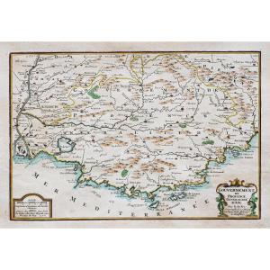
Representing the map of the GOVERNMENT OF ANTIBES, GRASSE, VALBONNE, NICE, etc... Beautiful original engraving, on steel with a burin and laid paper, by Nicolas TASSIN Hand watercolored Dimension(s): [...]
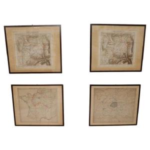
Late 19th century set of four antique geographical maps relating to the positioning of the armies in the Franco-German War 1870-71.
Author: Historical Section of the Great General Staff.
Publisher: [...]
Epreuve originale réalisée vers 1750. Anonyme.
Une partie de la marge latérale gauche rapportée anciennement.
1 pli ancien dans l’angle inférieur gauche.
Bon état.
Format feuille : 46 x 38 cm.
Fo[...]
Epreuve originale réalisée en 1690. Visscher cartographe.
Beaux coloris anciens.
Restauration ancienne du cartouche de titre rapporté.
Etat correct.
Format feuille : 65 x 51,5 cm.
Format cuivre :[...]
Epreuve originale réalisée en 1726. Nicolas de Fer cartographe.
Limites colorées de l’époque.
Restauration d’un manque de papier sur 1cm au niveau de la ville de Tours, avec légende manuscrite ajout[...]
Drawn and handwritten map from 1823 of the Kingdom of France (under the reign of Charles X). Very beautiful work of cartography signed and dated, recent framing.
Epreuve originale réalisée vers 1760.
Coloris aquarelle.
Rousseurs éparses.
Bon état.
Format feuille : 35 x 25 cm.
Format gravure : 22 x 19,5 cm.
Original antique chart of 1760
Vous pouvez co[...]
Switzerland with its subjects and allies from the best authorities.
Epreuve originale réalisée en 1807. J. Barlow graveur.
Coloris anciens.
2 rousseurs claires dans la marge supérieure n’atteignant[...]
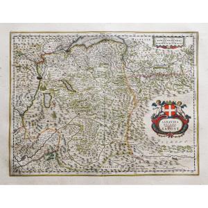
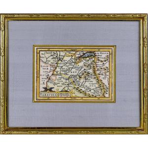
BEAUTIFUL and RARE regional map of SAVOIE - Beautiful ornamental title cartridge and a second cartridge with the scale of the map. The map was published around 1618 in a French edition of the work of [...]
Epreuve originale réalisée en 1616. Bertius graveur et Hondius éditeur.
Beaux coloris aquarelle.
Texte en latin au verso.
Très bon état.
Format feuille : 20 x 12,5 cm.
Format gravure : 14 x 9,5 c[...]
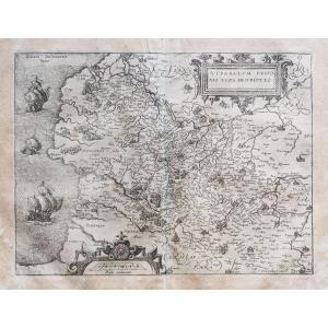
Epreuve originale réalisée vers 1588. Guicciardini géographe.
Rousseurs uniformes sur la carte et quelques plis anciens dans les marges.
Etat correct.
Format feuille : 38,5 x 34 cm.
Format gravure[...]
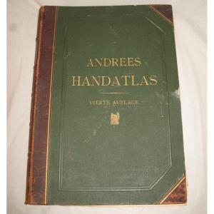
Handatlas de Andrees Collection of maps in German language dated 1899 Comprising 126 maps in plano and 137 side maps 4th edition by A. Scobel in Leipzig Drawing board type binding in strong cardboard [...]
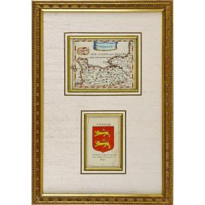
RARE MAP of NIVERNOIS accompanied by the COAT OF COAT (Banded in gold and azure, with the engrailed border of Gueules) of this same region. By Pierre DU VAL D'ABBEVILLE, geographer to His Majesty LOUI[...]
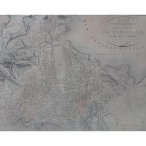
Engraving plan of the city of Marseille and its suburbs in 1818 engraved by Vicq. The sheet is stretched on cardboard from the beginning of the 19th century and is slightly insolated. It has a tear in[...]
Superb map of Kiel Schleswig (Gottorpia) taken from the atlas of world cities after Joris Hoefnagel, hand watercolored, mounted in a quality modern frame with Marie-Louise. Old edition, very good cond[...]
Superb map of Papa taken from the atlas of cities of the world according to Joris Hoefnagel, hand watercolored, mounted in a quality modern frame with Marie-Louise. Old edition, very good condition, f[...]
Superb map of Veletri (Blitri) taken from the atlas of world cities after Joris Hoefnagel, hand watercolored, mounted in a quality modern frame with Marie-Louise. Old edition, very good condition, fre[...]
Superb map of Regensburg taken from the atlas of world cities after Joris Hoefnagel, hand watercolored, mounted in a quality modern frame with Marie-Louise. Old edition, very good condition, fresh col[...]
Superb map of Kiel (Chilonium) taken from the atlas of world cities after Joris Hoefnagel, hand watercolored, mounted in a quality modern frame with Marie-Louise. Old edition, very good condition, fre[...]
Proantic uses a cookie to analyze traffic and improve its service by using Google Analytics. Data sent to Google Analytics (frequency of visits to the site and pages visited) are anonymous. No other cookie tracks your activity, your personal data is not collected. Thank you for helping us to have better understanding how Proantic is used.


 Le Magazine
 Rivista Artiquariato
 TRÉSORS magazine


